

Support for Deutsche Bahn Signals in TerraMatch from version 026.004
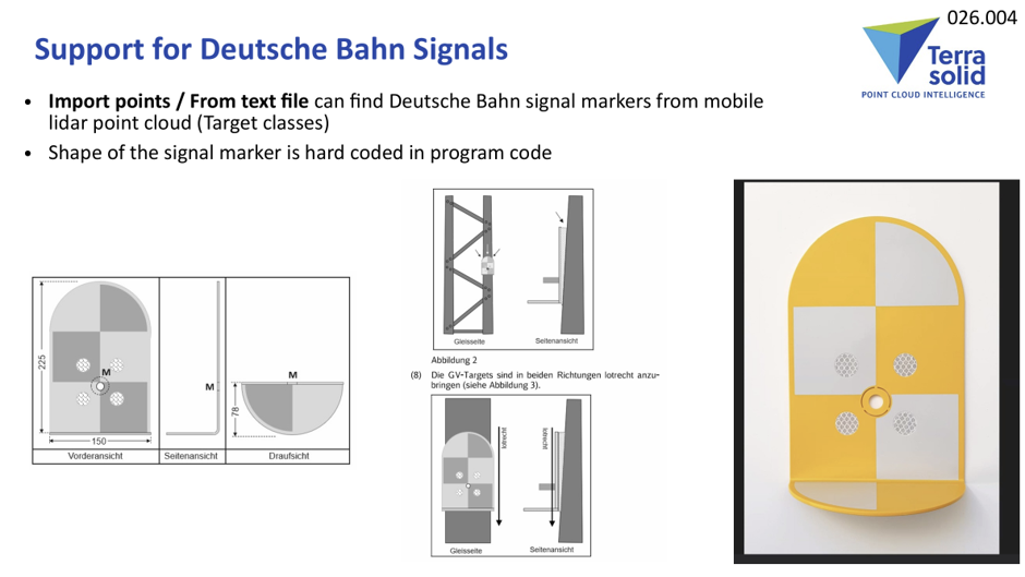
TerraMatch 026.004 introduces built-in support for Deutsche Bahn signal markers, standardized metal plate markers used throughout German railroads. The feature allows users to automatically detect these markers from mobile LiDAR point clouds and use their known XYZ coordinates as control points for trajectory adjustment.
- How It Works
The Deutsche Bahn signal marker shape is hard-coded in TerraMatch, so users do not need to define the marker geometry manually.
Known signal coordinates are imported from a text file, while TerraMatch searches the mobile LiDAR point cloud for the corresponding physical markers.
The workflow uses:
- Known XYZ signal coordinates
- Mobile LiDAR point clouds
- Trajectory data
- Target classes
- Signal marker geometry built into TerraMatch
The result is a set of observations that can be used to calculate and apply fluctuating XYZ trajectory corrections.
- Preparing the Data
Before searching for the signal markers:
- Import trajectories into the TerraMatch project.
- Import the mobile LiDAR point cloud.
- Classify the point cloud appropriately:
- Classify everything to the default class.
- Deduce line numbers.
- Assign intensity color to black points.
- Estimate the largest mismatch between the point cloud and known signal coordinates.
- Optionally, apply a systematic shift by line to reduce the initial mismatch.
Reducing the initial mismatch can produce cleaner observations and significantly reduce manual editing later.
- Preparing the Signal Coordinate File
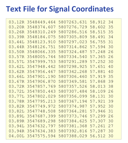
The known signal coordinates are provided as a text file.
The main columns are:
| Column | Description | ||
| Identifier | Signal marker identification | ||
| Easting | X / Easting coordinate | ||
| Northing | Y / Northing coordinate | ||
| Elevation | Z / elevation | ||
| Bolt length | Signal marker bolt length |
Bolt length can be specified either as an integer value in millimeters or as a decimal value in meters.
- Automatic Search Settings
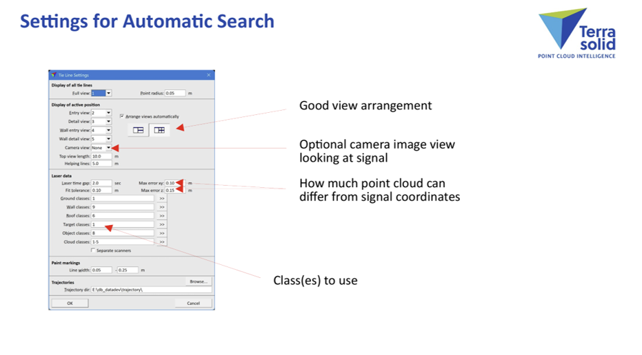
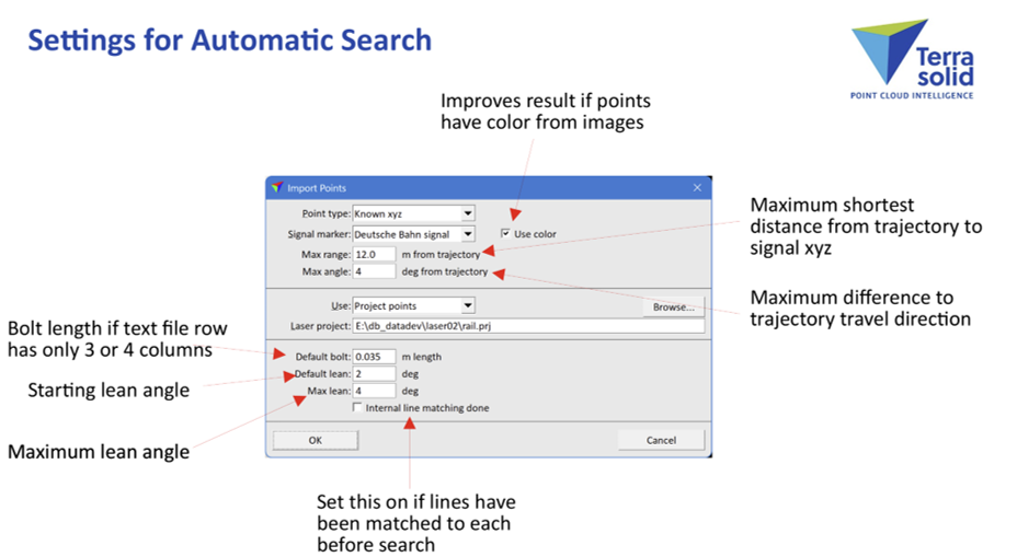
The Import points / From text file function contains settings specifically for automatically finding the Deutsche Bahn signal markers.
Important parameters include:
- Point cloud classes to search
- Maximum point-cloud difference from the known signal coordinates
- Bolt length when the text file contains only three or four columns
- Starting lean angle
- Maximum lean angle
- Maximum shortest distance from the trajectory to the signal XYZ position
- Maximum difference between the signal direction and trajectory travel direction
- Internal line matching option
A good view arrangement makes it easier to inspect detected signals manually. An optional camera-image view can also be useful when imagery is available.
Using point-cloud color from images can improve the automatic search result.
- Matching Workflow 1 — Direct Signal Matching
This workflow is recommended when the mobile LiDAR drive passes do not have significant overlap.
Step 1 — Search for signal markers
Run: Import points → From text file
TerraMatch automatically searches the point cloud for the Deutsche Bahn signal markers using the known XYZ coordinates.
Step 2 — Clean the tie lines
After detection:
- Reduce tie lines to a single line.
- Sort tie lines by line and time.
- Use Position → Filter bad to flag observations with mismatches.
Step 3 — Review observations
Manually inspect the flagged observations and correct or remove problematic measurements.
Continue until the observations match the expected smoothed correction curve.
Step 4 — Solve the correction
Solve and apply the fluctuating XYZ correction.
This workflow provides a straightforward way to use physical railway markers as control points for trajectory correction.
- Matching Workflow 2 — Internal Line Matching First
For projects where drive passes have a lot of overlap, a two-stage workflow can provide cleaner results.
Step 1 — Match drive passes to each other
First, search for internal XYZ elevation-grid cloud-to-cloud tie lines to match the different drive passes.
Solve and apply the fluctuating XYZ correction.
This reduces the mismatch between overlapping drive passes before searching for the physical signal markers.
Step 2 — Search for Deutsche Bahn signals
Run: Import points → From text file with Internal line matching enabled.
TerraMatch will use all drive passes together as one observation when searching for the signal markers.
Why use this workflow?
Matching the drive passes first provides several advantages:
- Smaller mismatch to the known signal coordinates
- Cleaner signal observations
- Better use of overlapping drive passes
- Less manual editing
- More reliable signal-marker detection
Step 3 — Clean and inspect
After the automatic search:
- Move the points used to find the signal marker if necessary.
- Sort tie lines by line and time.
- Flag mismatches using Position → Filter bad.
- Check and manually fix flagged observations.
- Continue until the observations follow the smoothed correction curve.
- Create the rubbersheet correction and apply it.
- Which Workflow Should You Use?
| Project condition | Recommended workflow |
| Drive passes have little overlap | Workflow 1: Direct signal matching |
| Drive passes have substantial overlap | Workflow 2: Internal line matching first |
The second workflow is particularly useful for dense railway mobile-mapping projects where multiple drive passes cover the same track sections.
Conclusion
With Deutsche Bahn signal support in TerraMatch 026.004, standardized railway signal markers can be used as known control points for mobile LiDAR trajectory correction.
The combination of automatic signal-marker detection, trajectory data, internal line matching, and fluctuating XYZ correction provides an efficient workflow for bringing mobile LiDAR data into alignment with known railway reference coordinates—while minimizing manual editing