

Digital Roads
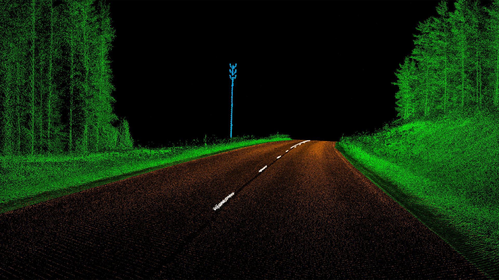
Millions of people use roads every day all over the world. Roads, like many other structures, have an estimated durability. Very often the roads carry traffic and heavy goods vehicles which were not predicted when the traffic was first estimated. That creates a lot of problems with technical conditions and the infrastructure must be constantly improved. Therefore, the mapping of road surface using high-resolution laser scanning sensors and cameras are gaining interest because they can acquire data quite fast and almost without gaps. Nowadays, detailed point cloud is required for 3D infrastructure geometry extraction for purposes of road network maintenance (Figure 1).
Within Terrasolid software the tools for processing dense 3D data and image information of roads have been developed significantly since more and more data became available from mobile mapping system surveys. Method for matching drive paths based on a mobile platform is available within TerraMatch application, where correction value calculation can be either based on surface matching or on different types of tie lines. Furthermore, TerraPhoto is used to calibrate mobile multiple-camera systems, to improve the positioning of the images from several cameras of a system, to rectify images on the ground surface, to create source data for coloring MLS point clouds, as well as producing fly-through movies. TerraScan offers tools for estimating the condition of a road and its parameters such as max deviation, edge slope, roughness, max rut, as well as various visualization possibilities. Point clouds loaded in TerraScan can be used to create a surface model in TerraModeler. TerraModeler enables editing any of the surface models interactively, surface model visualization by generating contours, drawing colored triangles, shaded surfaces, colored grid displays, slope arrows and numerical representations of elevation points.
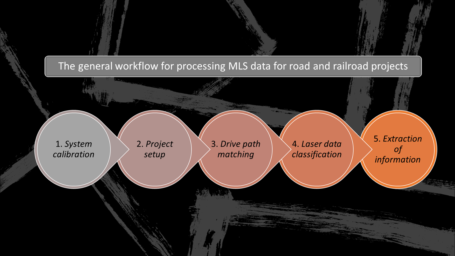
The general workflow for processing MLS data for road projects can be outlined as follows (Figure 2):
- System calibration: fine-tuning of the calibration values provided by system manufacturers. This is usually done based on laser data that is collected at a specific calibration site. The process is done with TerraScan and TerraMatch and the workflow is described in the TerraMatch Users’ Guide.
- Project setup: import and modify raw trajectory information, creation of a TerraScan project, import of raw laser data. This is done with tools of TerraScan.
- Drive path matching: improving the internal and absolute accuracy of the project data. This involves TerraScan and (optionally) TerraPhoto, but mainly tools of TerraMatch are used and the workflow is described in the TerraMatch Users’ Guide.
- Laser data classification: cutting off overlap between drive paths, apply classification routines and possibly other automatic/manual processing steps. This depends on the purpose for which the data shall be used.
- Extraction of information: this may include the analysis of the current situation, for example, on a road surface or along a road track; or the detection and/or vectorization of specific features, such as poles and paint markings (Figure 1), moving objects, road breaklines, overhead wires, or potentially dangerous objects, see also the list of applications below.
Applications
Road surface damage, such as ruts, cracks, potholes, etc. | Computation of road cross section parameters | Surface superelevation | Water flow on the road surface | Shape and condition of paint markings | Detection of longer depressions | Derive road alignment geometry for road design tasks | Line-of-sight analysis related to regulations for stopping and overpassing distances | Clearance areas under bridges, overhead wires, and in tunnels | Danger object detection along the road | Detection of road furniture objects, such as traffic signs, poles, bus stops, crash barriers, noise protection walls, etc. | Detection of moving objects | Room for snow | etc.
Digital Roads
Interested in LiDAR scanning regarding road construction and maintenance? Contact our sales with the form. We are happy to help and tell you more about our road and highway solutions.
Contact us
Guides for beginners and professionals
Learn more about how to use our products efficiently with the help of videos and user guides. The user guides for the applications are primarily published as webhelp. The PDF document is created in order to provide an offline version.
FAQ
I am text block. Click edit button to change this text. Lorem ipsum dolor sit amet, consectetur adipiscing elit. Ut elit tellus, luctus nec ullamcorper mattis, pulvinar dapibus leo.
I am text block. Click edit button to change this text. Lorem ipsum dolor sit amet, consectetur adipiscing elit. Ut elit tellus, luctus nec ullamcorper mattis, pulvinar dapibus leo.
I am text block. Click edit button to change this text. Lorem ipsum dolor sit amet, consectetur adipiscing elit. Ut elit tellus, luctus nec ullamcorper mattis, pulvinar dapibus leo.
I am text block. Click edit button to change this text. Lorem ipsum dolor sit amet, consectetur adipiscing elit. Ut elit tellus, luctus nec ullamcorper mattis, pulvinar dapibus leo.
I am text block. Click edit button to change this text. Lorem ipsum dolor sit amet, consectetur adipiscing elit. Ut elit tellus, luctus nec ullamcorper mattis, pulvinar dapibus leo.
I am text block. Click edit button to change this text. Lorem ipsum dolor sit amet, consectetur adipiscing elit. Ut elit tellus, luctus nec ullamcorper mattis, pulvinar dapibus leo.
I am text block. Click edit button to change this text. Lorem ipsum dolor sit amet, consectetur adipiscing elit. Ut elit tellus, luctus nec ullamcorper mattis, pulvinar dapibus leo.
I am text block. Click edit button to change this text. Lorem ipsum dolor sit amet, consectetur adipiscing elit. Ut elit tellus, luctus nec ullamcorper mattis, pulvinar dapibus leo.
I am text block. Click edit button to change this text. Lorem ipsum dolor sit amet, consectetur adipiscing elit. Ut elit tellus, luctus nec ullamcorper mattis, pulvinar dapibus leo.
I am text block. Click edit button to change this text. Lorem ipsum dolor sit amet, consectetur adipiscing elit. Ut elit tellus, luctus nec ullamcorper mattis, pulvinar dapibus leo.
I am text block. Click edit button to change this text. Lorem ipsum dolor sit amet, consectetur adipiscing elit. Ut elit tellus, luctus nec ullamcorper mattis, pulvinar dapibus leo.
I am text block. Click edit button to change this text. Lorem ipsum dolor sit amet, consectetur adipiscing elit. Ut elit tellus, luctus nec ullamcorper mattis, pulvinar dapibus leo.