

TerraScan User Guide
New project
Not UAV
New project command creates a new project definition. The complete project definition includes some descriptive information and a list of block boundaries. For the definition of block boundaries see Add by boundaries.
To create a project definition:
1. Select New project command from the File pulldown menu.
This opens the Project Information dialog:
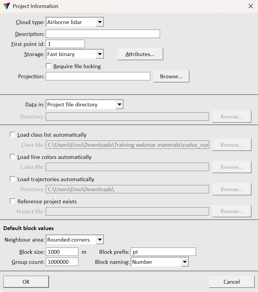
2. Define settings and click OK.
SETTING |
EFFECT |
|---|---|
Cloud type |
Cloud type: Airborne lidar, Mobile lidar, Stationary lidar, Airborne photo, Mobile photo, Stationary photo, Boat sonar or Mixed. |
Description |
Descriptive text for the project. |
First point id |
Start ID number for the laser data file. |
Storage |
Block binary file format: FastBinary, Scan binary 8 bit, Scan binary 16 bit, LAS 1.x, LAZ 1.x, GeoTIFF. For more information see Choosing a project storage format. |
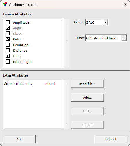
Attributes |
Opens the Attributes to store dialog. Only active attributes are stored in project block laser point files that belong to the project. |
Require file locking |
If on, a project block file is marked as locked when a user opens it for modification with the Open block command. For more information see File locking. |
Projection |
Projection system of the point cloud data for processing. To change the projection system, click on the Browse button. This opens the Browse for Projection System dialog. The dialog provides a search option for projection systems as well as a list of all implemented systems. In addition, any user-defined projection systems are included in the list. If another projection system is used for the data to import into the project, a projection change transformation will be applied during the import process. |
Data in |
Defines how the directory for the referenced laser data files is determined: •Project file directory - laser files are stored in the same directory as the project file. This is independent of the absolute path of the data and is therefore good in a network environment or when moving the data set from one computer to another. •Separate directory - laser files are stored at the location given in the Directory field. |
Load classes automatically |
If on, the defined Class file is automatically loaded with the project. |
Load line colors automatically |
If on, the defined Color file for line colors is automatically loaded with the project. |
Load trajectories automatically |
If on, trajectories from the given Directory are loaded automatically with the project. |
Reference project exists |
If on, the given Project file is defined as reference project to be used in corresponding tools, such as Compare with reference command. |
Neighbour area |
Defines the shape of the areas from neighbouring blocks that are seen as neighbouring areas. Neighbouring areas are useful when performing calculations for points near the block boundaries. Neighbouring areas allow for example smooth ground class continuity on the block boundaries. |
Block size |
Size of rectangular, automatically created blocks. These blocks are created if points are imported from areas which are outside the pre-defined block boundaries. |
Group count |
Amount of group numbers available for one block in the project. Determines also the first group number of the first block (= lowest group number in a project). Effects the Assign groups commands or corresponding macro steps. |
Block prefix |
Prefix of block names that is used for automatically created block boundaries. |
Block naming |
Block name definition for automatically created block boundaries. The list contains Number as automatic numbering option and any user defined Block naming formulas defined in TerraScan Settings. |
Choosing a project storage format
TerraScan supports multiple file formats from which you need to select one to be used for the block binary files. The best choice depends on a few factors:
•FastBinary is the best format for processing data in TerraScan.
•If your project is static ground-based, you must choose FastBinary.
•If you need to transfer the laser files to other applications, the best choice is LAS 1.x which is an open industry standard format and usually used for laser data exchange. The version of the LAS format mainly depends on the attributes you want to store for each point.
•If your raw data is LAS 1.4 and you need to deliver in LAS 1.4, use LAS 1.4. Otherwise, it's recommended to use FastBinary for processing and export into LAS 1.4 for data delivery.
•If you want to store the data in compressed files, use an LAZ 1.x format. This reduces storage space requirements significantly and thus, is a good option for data delivery and archiving.
•Coordinate system information is read from and written into Fast Binary and LAS/LAZ files.
•Scan binary 8 bit and Scan binary 16 bit are outdated formats of TerraScan and no longer recommended to use. They are still available in the software to ensure compatibility with old data sets.
The dialog defines what attributes are stored for each laser point that belongs to the project. Only active attributes are stored. It depends on the selected storage format which attributes are available. Only the FastBinary format of TerraScan allows the storage of all available attributes.
When a new project is created, you normally activate attributes that are stored in the raw laser files and which you want to keep in the block binary files. You may also activate additional attributes if you already know that you need them later. However, the selection of active attributes can be modified later by using the Edit project information command.
In addition to the attributes, the dialog defines the format of Time stamps for the block binary files. If the selected format differs from the time stamp format of the raw laser files, the time stamps are converted into the format defined in the project definition. The conversion is done during the import of the raw laser files into the project.
If Color values are stored for the block binary files, another selection is required for the amount of color channels. TerraScan can extract up to 10 color channels for each point. The maximum amount of color channels can only be stored in the TerraScan FastBinary format. LAS 1.4 format and later can store up to 4 color channels, LAS 1.2 format and later up to 3. If more than 3 channels are extracted, color values are stored as 16-bit values.
In addition to the standard attributes defined for LAS formats, you can store Distance, Group and Normal vector attributes in LAS 1.2+ and LAZ 1.2+ file formats.
You can store Riegl Extra Bytes, such as Pulse width and Amplitude attributes, in FastBinary, LAS 1.2+, or LAZ 1.2+ formats. The formats store the Riegl Pulse width as Echo length attribute and the Riegl Amplitude as Amplitude attribute.
You can store Riegl Extra Bytes, such as Reflectance, Amplitude and Pulse shape deviation attributes, in FastBinary, LAS 1.4, or LAZ 1.4 formats. The formats store the Riegl Reflectance as Reflectance attribute, the Riegl Amplitude as Amplitude attribute and the Riegl Pulse shape deviation as Deviation attribute.
You can store Agisoft Confidence values in FastBinary, LAS or LAZ file formats. TerraScan stores the value as Reliability attribute.
Other, arbitrary extra attributes can be included by specifying the Extra attributes in the bottom field. The field is available only for FastBinary and LAS/LAZ 1.2+ formats, which support the extra bytes. The attributes can be specified manually, specifying the exact name and value format used in the files. Alternatively, the attributes can be populated from a sample point cloud file containing the desired attributes using the Read file command.
TerraScan supports a simple way of file locking for block binary files. The file locking should prevent two people from modifying the same data at the same time in a work group environment.
The file locking is active if Require file locking is switched on in the project definition. This is only needed if you have multiple people working on the same data set in a network.
TerraScan implements file locking in a simple manner. It does not lock the laser file itself. It creates a temporary file which shows that the laser file is undergoing modification. The temporary file has the same name and storage location as the block binary file and has the extension .LCK. This temporary file contains the name of the computer which has opened the laser file for modification. The creation time of the temporary file shows when the laser file was opened.
This relaxed locking method does not completely prevent modification of a laser file that has been locked. Only most of the TerraScan tools refuse to modify the data. Other applications do probably not recognize that the laser file is locked by TerraScan.
Example case
When file locking is active, the project storage directory might contain the following files:
BLOCK BINARY FILE |
TEMPORARY LOCK FILE |
|---|---|
h:\otaniemi\ota000317.fbi |
h:\otaniemi\ota000317.lck |
h:\otaniemi\ota000318.fbi |
|
h:\otaniemi\ota000319.fbi |
h:\otaniemi\ota000319.lck |
h:\otaniemi\ota000320.fbi |
|
The above files would indicate that blocks 000317 and 000319 are modified and locked.
Operations supporting file locking
The following actions lock a block binary file:
•Open block command if Open for is set to Modification.
•Read points command when opening a single block binary file.
•Load Airborne Points tool when opening a single block binary file.
•Load Ground Points tool when opening a single block binary file.
•Executing Adjust to geoid from the Project window.
•Executing Run macro from the Project window with a Save points setting on.
The same actions also check whether a laser file is locked or not.
Releasing a lock
The Project window has a Release lock command in the Block pulldown menu for releasing a locked block. The command releases a lock only if a file has been locked on the same workstation or if the locking was done more than 24 hours ago.
As a last precaution, the lock can be released by deleting the .LCK file.