

TerraScan User Guide
Add by boundaries
Not UAV
Add by boundaries command adds block boundaries to a project definition. This is usually the second step of the project creation after defining settings of the project itself.
Block boundaries can be created using CAD drawing tools for closed elements, or using one of the tools provided by TerraScan, such as Design Block Boundaries, Create along centerline, or Create along tower string.
The command lets you define names for the blocks. The same names are used for the block binary files which are created by importing points into the project. The names can contain a prefix and a unique, automatically derived number for each block. CAD text elements drawn inside the boundaries of each block can be used as names as well. Alternatively, a naming method can be defined in the Block naming formulas category of TerraScan Settings.
To add block boundaries to the project definition:
1. Select shape elements and (optional) text elements inside the shapes using the Selection tool.
2. Select Add by boundaries command from the Block pulldown menu.
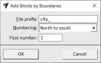
This opens the Add Blocks by Boundaries dialog:
3. Define settings and click OK.
This adds the blocks to the project definition. Use Save project or Save project as commands in order to save the block boundaries in a project file.
SETTING |
EFFECT |
|---|---|
File prefix |
Prefix for the names of project blocks and related block binary files. |
Numbering |
Method of assigning names or name parts to blocks: •Selection order - automatic numbering increases in the same order as boundary shapes have been selected. •North to south - automatic numbering increases geographically from north to south and secondarily west to east. •South to north - automatic numbering increases geographically from south to north and secondarily west to east. •West to East - automatic numbering increases geographically from west to east and secondarily south to north. •East to West - automatic numbering increases geographically from east to west and secondarily south to north. •Trajectory order - automatic numbering increases according to the order of data capturing. The time of data capturing is derived from the active trajectories in TerraScan. •Selected numbers - the name is defined by a unique numerical text element that is placed inside each block boundary. •Selected strings - the name is defined by a text element that is placed inside each block boundary. The list may further include Block naming formulas that are defined in TerraScan Settings. |
First number |
Number of the first block to add. This is only considered if a method of automatic block numbering is selected in the Numbering list. |