

TerraScan User Guide
Adjust to geoid
Not UAV
Adjust to geoid command adjusts the elevation values of the block binary files to a local elevation model. The geoid model can be defined by an implemented geoid model, a text file, a TerraModeler surface, or a selected linear chain.
The theory of geoid adjustment and the use of the command in TerraScan are explained in detail in section Geoid adjustment.
The command performs the same action on block binary files as the Adjust to geoid command on loaded points.
To run elevation adjustment on project blocks:
1. (Optional) Select block definitions in the Project window to be adjusted.
2. Choose Adjust to geoid command from the Tools pulldown menu.
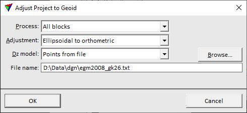
This opens the Adjust Blocks to Geoid dialog:
3. Define settings and click OK.
This starts the adjustment process. The process effects the block binary files directly on the hard disc. It might be advisable to create a backup copy of the block binary files before starting the process.
SETTING |
EFFECT |
|---|---|
Process |
Blocks to adjust: •All blocks - all blocks in the list. •Selected blocks - selected blocks only. |
Adjustment |
Direction of the elevation adjustment: •Ellipsoidal to orthometric - adjustment from ellipsoidal to orthometric height values. This is the normal way of an geoid adjustment. •Orthometric to ellipsoidal - adjustment from orthometric to ellipsoidal height values. This is the reverse way of an geoid adjustment. |
Dz model |
Source file that provides the geoid correction model: •Points from file - space separated X Y dZ text file as described in Introduction to geoid adjustment. •ISG geoid file - a geoid file in isg format. •Selected linear chain - linear element selected in the CAD file. •<name> - name of a geoid model loaded as surface in TerraModeler. •<implemented model> - name of an implemented geoid model. |
File name |
Name of the geoid text file. This is active only if Dz model is set to Points from file. |
Extend |
Distance from a selected linear element by which the linear chain is extended for elevation value corrections. This is active only if Dz model is set to Selected linear chain. |
Projection |
Projection system of the geoid model. This is active only if Dz model is set to any implemented geoid model. |