

TerraScan User Guide
Add using files
Not UAV
Add using files command creates a list of block definitions from a collection of FastBinary, LAS or GeoTIFF files. It can be used to create a TerraScan project for files that have been delivered as tiled point cloud but without project definition.
The process deduces the bounding box for each file from the file header and uses that as block boundary. Optionally, the block boundary can be adjusted to even coordinate values. The block boundary may be a bit inaccurate if the position of the point cloud has been modified, for example by TerraMatch processing. However, this is not critical for further processing steps.
To create block definitions from files:
1. Create a project definition. Use the format of the block binary files you want to use for block creation.
2. Save the project file in the same folder where the block binary files are stored.
3. Select Add using files command from the Block pulldown menu.
This opens the Add files to project dialog, a standard dialog for opening files.
4. Select all files you want to use for creating block definitions and click Open.
This opens the Adjust Block Borders dialog:
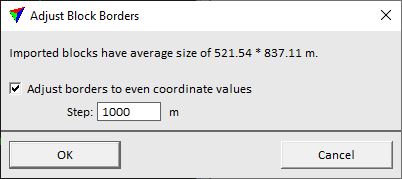
The dialog shows the average size of blocks that will be created.
5. (Optionally) Switch on the Adjust border to even coordinate values option and define a Step size for block corners. The Step value determines to which closest even coordinate values the block boundary is adjusted.
6. Click OK.
This adds the blocks to the project definition. Use Save project command in order to save the block definitions in a project file.