

TerraPhoto User Guide
Adjust positions
Not Lite
Adjust positions command adjusts the positions of the images in the active image list. The software tries to improve the match of the tie point rays from different images. This process is also called aerial triangulation. The adjustment can use tie points from a file or active tie points. The latter alternative requires that the Tie points window is open and tie points are active.
The adjustment can be applied to image orientation angles, image elevation, and/or image xyz positions. If the raw positioning of the images is good and based on GPS measurements, it is recommended to modify the orientation angles only. There is a high correlation between xy and roll/pitch adjustments. The adjustment of both is reliable only if there is a very good number of tie points for each image.
Positional adjustment of the images can be performed with the following goals in mind:
•Improve camera calibration parameters. You can make changes to camera misalignment angles or principal point z based on the adjustment report.
•Find bad tie points. Bad tie points cause bigger changes to raw positioning which are highlighted in the report if you specify suitable flagging limits. Furthermore, when you have adjusted image positioning, bad tie points stand out by having larger mismatch values.
•Produce an adjusted image list which provides more accurate image positioning. This image list should be saved as its own file and can be used for orthorectification or for vectorization tasks.
•Derive fluctuating corrections from aerial images that can be applied to a point cloud, trajectories, TerraMatch tie lines and an image lists with the Apply correction tool of TerraMatch. This is applicable if the collection of images and point cloud was done during the same flight and if the initial positioning of images and point cloud is based on the same GPS/IMU solution.
To adjust image positioning using tie points:
1. Select Adjust positions command from the Images pulldown menu.
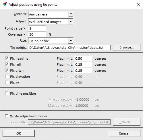
This opens the Adjust position using tie points dialog:
2. Define settings and click OK.
This starts the adjustment process. After the process has finished, the Tie point adjustment report is displayed.
3. Select Save list As commands from the Images pulldown menu in order to save the image list into a new file.
SETTING |
EFFECT |
|---|---|
Camera |
Name of the camera for which to apply the adjustment. Alternatively, images from Any camera can be adjusted. |
Adjust |
Images that are effected by the adjustment: •All images - all images in the active image list that have tie points. •Well defined images - images that have enough tie points to meet the given Point value and Coverage limits. •Selected - selected images only. This requires the selection of images in the image list before the command is started. |
Point value |
Required Tie point values for images to be adjusted. This is only active if Adjust is set to Well defined images. |
Coverage |
Required Tie point distribution for an image to be adjusted. This is only active if Adjust is set to Well defined images. |
Use |
Source of tie points: Active tie points or Tie point file. |
Tie points |
File from which to read tie points. This is only active if Use is set to Tie point file. |
Fix heading |
If on, the process modifies the heading angles of images. |
Fix roll |
If on, the process modifies the roll angles of images. |
Fix pitch |
If on, the process modifies the pitch angles of images. |
Fix elevation/scale |
If on, the process modifies the camera z coordinates of images. |
Fix xyz |
If on, the process modifies the camera xyz coordinates of images. |
Fix time position |
If on, the software tries to derive a time correction for the images. This works only for data sets for which the majority of images has correct time stamps and just a few images, for instance images of a single line, have incorrect time stamps. The correction for time stamps are within the given Min correction and Max correction values. |
Write adjustment curve |
If on, the changes are written to a text file that contains time stamps and adjustment values. This may be useful, for example, to find out whether there has been drift in the IMU measurement. The text file format corresponds to a TerraMatch solution file for fluctuating corrections. With the extension .TMS, the file can be used to apply fluctuating corrections in TerraMatch. The computation of the adjustment curve should be based on the TerraScan trajectories if corrections are applied to a point cloud as well. |
Adjust positions produces a report which plays a central role for optimizing camera parameters and for fine tuning tie points.
The start of the report may look like:
Start average 4.9789 cm
Final average 1.3724 cm
Start average indicates how well tie point rays match each other before the adjustment. This value is a measure of how good the raw positioning of images is, how good the camera calibration works, and how good the tie points are. Whenever you try to improve any of these factors, you aim to minimize the average mismatch.
Final average indicates how well tie point rays match each other after the adjustment. This value is primarily a measure of how good the camera calibration is and how good the tie points are.
The end of the report may look like:
Avg magnitude 0.0 0.0 0.0 0.039 0.010 0.009
Average +0.0 +0.0 +0.0 -0.000 -0.001 -0.000
Median +0.0 +0.0 +0.0 +0.000 -0.001 -0.000
Avg magnitude indicates how big the average changes to parameters are. These changes give an indication of the quality of the raw GPS/IMU trajectory information.
Average and Median give an indication if heading, roll, and pitch misalignment values for the camera are good. Average heading, roll and pitch changes should be practically zero if the misalignment values in the camera file are correct and if you have good tie points.