

TerraScan User Guide
Draw Slope Arrows
 Draw Slope Arrows tool computes the slope along an alignment element of a road. The computation can be done for the side slope of road lanes (representing the superelevation of the lane) or for the longitudinal slope of the road. The tool draws arrows which show the direction of the slope and text labels that show the gradient of the slope.
The tool requires a line string as alignment element. This is usually the approximate center line of the road which can be derived, for example, from the trajectory lines. The alignment element determines the longitudinal direction of the road as well as the horizontal location of the slope arrows. The elevation of the alignment element does not effect the slope arrows.
The elevation of the slope arrows is fitted to laser points on the road surface. Thus, these laser points should be classified into a separate class by using preferably the Hard surface classification routine. The gradient of a slope arrow is computed from the elevation values of the start and end points of the arrow element.
The tool requires points loaded into TerraScan. However, the same process can be performed for a TerraScan project using the Compute slope arrows macro action and then, reading the slope arrows from text files using the Read / Slope arrows command.
To draw slope arrows:
1. Load laser points into TerraScan. Only points on the road surface are required.
2. Select the alignment element with any Selection tool.
3. Select Draw Slope Arrows tool.
This opens the Draw Slope Arrows dialog:
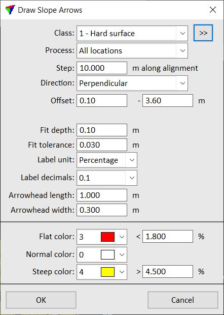
4. Define settings and click OK.
This starts the process. The software draws arrows and text elements along the alignment element wherever it finds laser data. The level, line weight, line style, and text size of the arrow and label elements are determined by the active symbology and text size settings in the CAD file.
An information dialog shows the number of created slope arrows.
SETTING |
EFFECT |
|---|---|
Class |
Point class that contains points on the road surface. Used for fitting the elevation of slope arrows. The list contains the active classes in TerraScan. |
|
Opens the Select classes dialog which contains the list of active classes in TerraScan. You can select multiple source classes from the list that are then used in the Class field. |
Process |
Area to process: •All locations - slope arrows are created wherever there is point cloud data available. •Inside active block - slope arrows are created only inside the active block. This excludes areas covered by neighbour points that are loaded in addition to the points of an active project block. |
Step |
Distance between locations where the software places a slope arrow. |
Direction |
Direction of the slope arrows relative to the alignment element or the road direction: •Longitudinal - in road direction. •Perpendicular - perpendicular to the road direction. |
Offset |
Defines the horizontal distance of the start and end point of an arrow relative to the alignment element. This is only one value for Longitudinal arrows and two values for Perpendicular arrows. The two offset values also determine the length of slope arrows with Perpendicular direction. Positive offset values create slope arrows to the right side of the alignment element, negative values to the left side. |
Length |
Length of slope arrows with longitudinal direction. This is active only if Direction is set to Longitudinal. |
Fit depth |
Depth of a section in the point cloud data where the software fits the arrow to the points on the road surface. |
Fit tolerance |
Tolerance value for fitting the arrow to the points. Relates to the noise in the data. |
Label unit |
Unit for expressing the slope gradient: Degree or Percentage. |
Label decimals |
Number of decimals for slope labels. |
Arrowhead length |
Length of the arrow head as part of the slope arrow. |
Arrowhead width |
Width of the arrow head. |
Flat color |
Color of a slope arrow if the slope gradient is less or equal to the given value. |
Normal color |
Color of a slope arrow if the slope gradient is between the given flat and steep values. |
Steep color |
Color of a slope arrow if the slope gradient is larger than the given value. |

You can undo the creation of slope arrows by using the Undo command of the CAD platform.