

TerraScan User Guide
Create along trajectories
Not UAV
Create along trajectories command creates block boundaries along trajectories. The trajectories must be active in TerraScan. The block length is measured along the trajectories and automatically adjusted according to the number of trajectories at one location. The block width is calculated from each trajectory line. If trajectories are closer to each other than half of the given block width, the width is computed from the outermost trajectories.
The method does not rely on laser data or data imported into a TerraScan project. It is best suited for MLS projects.
The resulting block boundaries can then be used to define blocks for a project with Add by boundaries command.
If the laser scanner has been switched off for some parts of the survey, the method may produce unnecessary blocks. This can be avoided by cutting off parts from the trajectories for which no laser data is available.
To create blocks along trajectories:
1. Load trajectories into TerraScan.
2. Select Create along trajectories command from the Block pulldown menu.
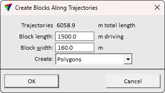
This opens the Create Blocks Along Trajectories dialog:
4. Define settings and click OK.
This draws the block boundaries as shapes into the CAD file. The elements are drawn on the active level using the active symbology settings of the CAD platform.
SETTING |
EFFECT |
|---|---|
Trajectories |
The length of the trajectories is displayed. |
Block length |
Maximum length of the blocks measured along the trajectories. If a place is captured multiple times, the block length becomes shorter automatically. |
Block width |
Width of the blocks. |
Create |
Element type to create: •Polygons - shape elements for direct use with Add by boundaries. •Outside parts - line elements bounding the data capture for boundary creation with Desing block boundaries. Useful for MLS and corridor mapping projects. |