

TerraScan User Guide
Create for polygon
Not UAV
Create for polygon command creates rectangular block boundaries covering polygon extent. After creating the boundaries, the shapes can be added to the project as block definitions using Add by boundaries -command.
To create blocks for polygon:
1. Select a shape with the Selection tool.
2. Select Create for polygon command from the Block pulldown menu.
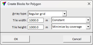
This opens the Create Blocks for Polygon dialog:
4. Define settings and click OK.
This draws the block boundaries as shapes into the CAD file. The elements are drawn on the active level using the active symbology settings of the CAD platform.
SETTING |
EFFECT |
|---|---|
Array type |
Tile pattern to construct: •Regular grid - regular tile pattern. The positioning is organized as multiple of the nominal tile size. •X axis filling - tiles are extended horizontally up to four times the defined width. Suits for designing tiles along a corridor while avoiding creation of small edge tiles. •Y axis filling - tiles are extended vertically up to four times the defined width. Suits for designing tiles along a corridor while avoiding creation of small edge tiles. |
Tile width |
Determines tile width: •Constant - all tiles have a constant width. •Minimize by coverage - width of the tiles created to the edges of the extent polygon minimized to cover the extent only. |
Tile height |
Determines tile height: •Constant - all tiles have a constant height. •Minimize by coverage - height of the tiles created to the edges of the extent polygon minimized to cover the extent only. |