

TerraPhoto User Guide
Import feature points
Import feature points command reads the feature point files that have been created with the Compute feature point command and converts them into Air tie points.
More information about feature points and their integration in the image adjustment workflow can be found in Chapter Working with Tie Points.
To import feature points:
1. Select Import feature points command from the File pulldown menu.
This opens the Import Feature Points dialog:
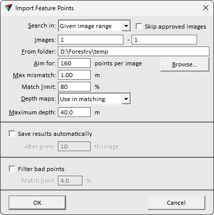
2. Define settings and click OK.
This opens the feature point files from the temporary files folder of the mission and converts them into Air tie points.
3. Save the tie points using Save or Save As commands from the File pulldown menu in order to save the tie points with renumbered images into a file.
SETTING |
EFFECT |
|---|---|
Search in |
Images for which the feature points are imported: •All images - all images on the image list. •Underdefined images - images not well defined with tie points according to the flagging limits. •Given image range - image numbers within defined range. |
Skip approved images |
If on, approved images are skipped in the import process. |
Images |
Image number range to include in feature point import. Available only if Search in is set to Given image range. |
From folder |
Feature point directory. |
Aim for |
Target amount of tie points per image. Images may get more tie points but less only if part of an image is not applicable for tie point placement. |
Max mismatch |
Maximum allowed mismatch value at a tie point position. |
Match limit |
Required match between images at a feature point location for accepting a tie point. The match refers to brightness of pixels in different images at the tie point location. Recommended values are between 50% and 80%. A smaller value results in more tie points but may lead to more bad tie points. A larger value results in less tie points that are probably more reliable. |
Depth maps |
Determines the usage of depth maps: •Do not use - no depth maps are used. This may lead to a higher amount of bad tie points. •Use in matching - depth maps are used for matching tie point positions. This may lead to a lower amount of bad tie points. It also speeds up the import process. |
Maximum depth |
Maximum distance from the image capture position to the target. Use to filter the use of feature points extracted from far away objects. |
Save results automatically |
If on, tie point file is saved during the import process with the specified frequency. |
Filter bad points |
If on, bad tie points are filtered out during the import process using the given Filter ratio. It might be better to keep this off and filter bad tie points later in a separate step. |