

TerraPhoto User Guide
Compute feature points
Not Lite
Compute feature points command creates feature point files for raw images. The process creates one file for each image with the extension .FPT. The files should be stored in the temporary files directory of the mission.
More information about feature points and their integration in the image adjustment workflow can be found in Chapter Working with Tie Points.
To start the feature point computation:
1. Select Compute feature points command from the Images pulldown menu.
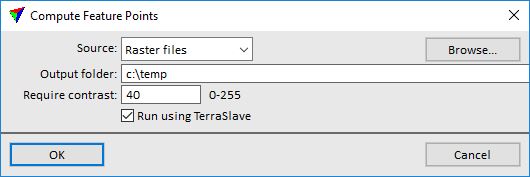
This opens the Compute Feature Points dialog:
2. Select settings.
SETTING |
EFFECT |
|---|---|
Source |
Determines which images are used for the feature point computation: •Image list - images that are referenced in an active image list. •Raster files - image files that are selected in a separate step. |
Output folder |
Directory for storing the feature point files. Use the temporary file directory of the mission. This ensures that the import command for feature points will find the files automatically. |
Require contrast |
Contrast between image pixels at a feature point location. A higher value avoids that feature points are placed in dark shadow or overexposed areas where there is low contrast. |
Run using TerraBatch |
If on, the process of feature point computation runs in TerraBatch. This is highly recommended for the processing- and time-intensive computation. The CAD platform and Terra applications will be available for other tasks as long as the computation process is running. |
3. Click OK.
If Source is set to Raster files, this opens the Source files dialog, a standard Windows dialog for selecting files.
4. Select all raw image files that shall be included in the feature points computation and click Open.
The feature point computation starts. The process may take some time if a larger number of images is involved.