

TerraScan User Guide
Transform
Transform command lets you interactively transform a point cloud. The transformation may include a translation and/or a 2D rotation. It may effect all scans or only one single scan.
To transform a point cloud:
1. Select Transform command from the Measurement pulldown menu.
This opens the Transform Measurement dialog:
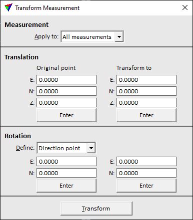
2. Define settings.
3. Click on the Transform button.
This transforms the point cloud to the new position.
SETTING |
EFFECT |
|---|---|
Apply to |
Points that are effected by the transformation: points from all scans or only from one specific scan. The list contains all scan numbers that are available in the loaded point cloud. |
Original point E|N|Z |
XYZ coordinates of the origin point for the translation. Click on the Enter button in order to define the coordinate values with a data click inside a CAD file view. Alternatively, type the values in the fields. |
Transform to E|N|Z |
XYZ coordinates of the target point for the translation. Click on the Enter button in order to define the coordinate values with a data click inside a CAD file view. Alternatively, type the values in the fields. |
Define |
Determines how the rotation is defined: •No rotation - no rotation is applied. •Easting axis - the direction of the easting (X) axis is defined. •Northing axis - the direction of the northing (Y) axis is defined. •Direction point - two points define the rotation direction. |
E|N |
If the rotation is defined by Easting or Northing axis, XY coordinates of the rotation target point. If Define is set to Direction point, the coordinates on the left side determine the origin point for the rotation and the coordinates on the right side the target point. |
The common transformation options of TerraScan can also be applied to the point cloud, for example, by using the Transform loaded points command.