

TerraScan User Guide
Fit point clouds
Fit point clouds command provides an option for automatically fitting one scan to another. The scans must be close to each other initially. The method is based on minimizing the offset between the surfaces in two scans.
To fit point clouds:
1. Select Fit point clouds command from the Measurement pulldown menu.
This opens the Fit Point Clouds dialog:
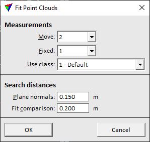
2. Define settings and click OK.
This fits the scans to each other if possible.
SETTING |
EFFECT |
|---|---|
Move |
Number of the scan that is moved to the other scan. The list contains all scan numbers that are available in the loaded point cloud. |
Fixed |
Number of the scan that is fixed and acts as reference. The list contains all scan numbers that are available in the loaded point cloud. |
Use class |
Point class that is used to fit the scans. |
Plane normals |
Neighborhood radius for computing the normal vectors defining the surfaces. The normals are derived from locally planar areas in the point cloud. |
Fit comparison |
Search radius for finding the corresponding surface in the other scan. Set to the position offset between the two scans. |