

TerraScan User Guide
Transform loaded points
Transform loaded points command applies a transformation to points loaded in TerraScan. The transformation can be applied to all points or to points of selected class(es), selected lines, and/or inside a fence or selected polygon.
The transformation can be defined in different ways:
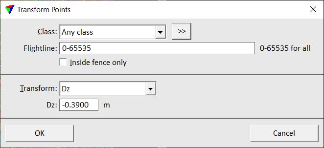
•Dz - fixed elevation difference value in order to apply a systematic elevation shift.
•Dxyz - text file storing difference values for easting, northing and elevation. The format of the text file is X Y dX dY dZ.
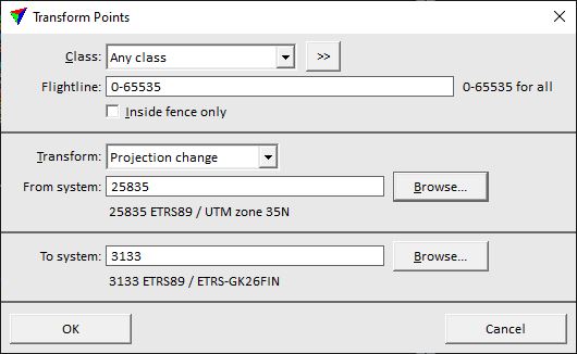
•Projection change - a source and a target projection system are selected from a list of implemented projection systems.
•Height from ground - elevation of each point is replaced by its height above ground. Ground is defined by points in one or more point classes.
•Height from TIN - elevation of each point is replaced by its height above a TIN model. The TIN model is defined by an active surface model in TerraModeler.
•Add TIN - elevation values of a TIN are added to the original elevation values of loaded points. The corresponds to an Adjust to geoid action which uses a TIN as geoid model. The TIN is defined by an active surface model in TerraModeler.
•Scale dZ from TIN - scaled elevation difference values between the loaded points and a TIN are added to the original elevation values of loaded points. The TIN is defined by an active surface model in TerraModeler.
•A specific transformation defined in Coordinate transformations / Transformations category of TerraScan Settings.
To transform loaded points:
1. Select Transform loaded points command from the Tools pulldown menu.
This opens the Transform Points dialog:
2. Define settings and click OK.
This modifies the coordinates of loaded laser points according to the selected transformation.
SETTING |
EFFECT |
|---|---|
Class |
Point class(es) for which the transformation is applied. |
|
Opens the Select classes dialog which contains the list of active classes in TerraScan. You can select multiple source classes from the list that are then used in the Class field. |
Line |
Line number(s) for which the transformation is applied. Use a comma or minus to separate several line numbers, for example 2-5,10. |
Transform |
Type of transformation. |
Dz |
Fixed value added to the original elevation values of loaded points. This is active only if Transform is set to Dz. |
File |
Text file that stores the XYZ correction values. This is active only if Transform is set to Dxyz. |
From system |
Source projection system. Click on the Browse button to open the Browse for Projection System dialog. The dialog provides a search option for projection systems as well as a list of all implemented systems. In addition, any user-defined projection systems are included in the list. |
To system |
Target projection system. Click on the Browse button to open the Browse for Projection System dialog. The dialog provides a search option for projection systems as well as a list of all implemented systems. In addition, any user-defined projection systems are included in the list. |
Ground |
Point class(es) defining the ground surface from which height values are derived. This is active only if Transform is set to Height from ground. |
|
Opens the Select classes dialog which contains the list of active classes in TerraScan. You can select multiple source classes from the list that are then used in the Ground field. This is active only if Transform is set to Height from ground. |
Surface |
Surface model name that defines the TIN surface from which height values are derived. Requires an active surface model in TerraModeler. This is active only if Transform is set to Height from TIN, Add TIN, or Scale dZ from TIN. |
Scale |
Scale factor for exaggerating elevation differences between loaded points and a TIN model. This is active only if Transform is set to Scale dZ from TIN. |

Both, the original and the final coordinates must fit inside the coordinate value ranges defined in Define Coordinate Setup tool.