

TerraScan User Guide
Import Road Breaklines
Not Spatix
 Import Road Breaklines tool converts linear elements from an artificial coordinate system into geographic coordinates. It is used in combination with digitized lines based on TerraScan section points which are produced by the Write section points macro action.
The line elements are digitized in an artificial coordinate system in a separate CAD file. The artificial coordinate system is defined by:
•X axis - scaled stations along an alignment element.
•Y axis - offset from an alignment element.
•Z axis - scaled elevation values of the original point cloud data.
The tool converts these artificial XYZ coordinates back to Easting, Northing, Elevation coordinates. It utilizes the same alignment element and inverse scaling factors as were used for producing the section points.
To import road breaklines:
1. Attach the section CAD file as a reference to the normal project CAD file.
2. Open two top views, one showing the location of the road and the alignment element used for creating section points, and the other one showing the digitized lines in the attached reference CAD file.
3. Select the alignment element using any Selection tool.
4. Draw fence around the lines in the reference CAD file.
5. Select Import Road Breaklines tool.
This opens the Import Road Breaklines dialog:
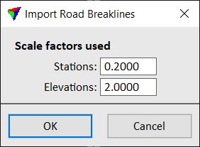
6. Define settings. The values must be the same as used for creating the section points with the Write section points macro action in order to compute correct coordinate values for the breakline elements.
7. Click OK.
This converts the lines inside the fence from the artificial coordinates to the original coordinates and draws them into the master CAD file.
SETTING |
EFFECT |
|---|---|
Stations |
Scale factor along the alignment element. Used for decompressing the digitized lines to their normal length. |
Elevations |
Scale factor for elevation values. Used for resolve the exaggeration of elevation values of the digitized lines. |
At the moment, reference files and thus, the Import Road Breaklines tool can only be handled in Bentley CAD. There is not yet a comparable concept in Spatix.