Draw Plane Section
 Draw Plane Section tool lets you set up a section that contains points on a plane. The user defines one or several circular sample locations in the point cloud from which the software derives a plane equation. Then, the software checks which points fit to the same plane and draws them into a section view. The tool can be used for drawing a section of any 3D plane.
The tool may be useful, for example, for manual 3D digitization work in a point cloud. In order to digitize the planar part of traffic signs, you can draw a plane section of the sign plate and digitize its boundary in the section view.
To draw a plane section:
1. Start Draw Plane Section tool.
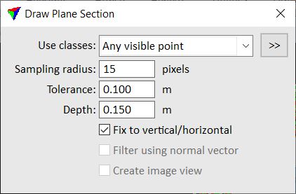
This opens the Draw Plane Section dialog:

2. Define settings.
3. Place a data click in a view that displays the point cloud. This can be a top or section view.
This computes the plane equation from the points inside the sample radius and highlights the are in which the points fit to this plane.
4. (Optional) Place more data clicks in the same view in order to refine the plane selection.
5. Place a data click into another view in order to draw the plane section.
This displays the points that fit to the plane in the section view.
SETTING |
EFFECT |
|---|---|
Use classes |
Point class(es) that must fit to the plane. |
|
Opens the Select classes dialog which contains the list of active classes in TerraScan. You can select multiple source classes from the list that are then used in the Use classes field. |
Sampling radius |
Radial distance from a data click. The plane equation is derived from the points that are inside the sample radius. |
Tolerance |
Distance by which points are allowed to differ from a perfect plane. Points that are within the tolerance distance are consider as points belonging to the plane. |
Depth |
Display depth of the plane section on both sides of the section's center line. |
Fix to vertical/horizontal |
If on, the software forces the plane to be exactly vertical or horizontal if all points of the plane are within two degree from vertical/horizontal. |
Filter using normal vector |
If on, only points of planar dimension are used for drawing the plane section. This requires the computation of normal vectors for the points. |
Create image view |
If on, an image is displayed in the background of the plane section view. This requires that TerraPhoto is available, and that a mission and image list are loaded. See TerraPhoto User Guide for more information. |
