

TerraScan User Guide
Read / Section parameters
Read / Section parameters command reads text files that have been created in an automatic process for extracting road section parameters. It is used to draw the section parameter values into the CAD file. See Compute section parameters macro action for more information about section parameters and the creation of section parameter text files.
The section parameter values are drawn as text and linear elements into the CAD file. The settings in Road section parameters category of TerraScan Settings determine level, color, text size and unit definitions of the parameters.
To read section parameters into the CAD file:
1. Select Read / Section parameters command from the Tools pulldown menu.
This opens the Section parameter files dialog, a standard dialog for opening files.
2. Select section parameters text files and click Open.
This opens the Read Section Parameters dialog:
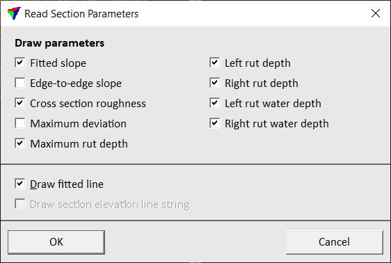
3. Define parameters that you want to draw and click OK.
This reads the text files and draws the section parameter values into the CAD file.
SETTING |
EFFECT |
|---|---|
Fitted slope |
If on, the fitted slope value of a section is drawn as text element. |
Edge to edge slope |
If on, the edge-to-edge slope value of a section is drawn as text element. |
Cross section roughness |
If on, the roughness value of a section is drawn as text element. |
Maximum deviation |
If on, the maximum deviation value of a section is drawn as text element. |
Maximum rut depth |
If on, the maximum depth value of ruts at a section location is drawn as text element. |
Left rut depth |
If on, the depth value of the left rut at a section location is drawn as text element. |
Right rut depth |
If on, the depth value of the right rut at a section location is drawn as text element. |
Left water depth |
If on, the water depth value of the left rut at a section location is drawn as text element. |
Right water depth |
If on, the water depth value of the right rut at a section location is drawn as text element. |
Draw fitted line |
If on, the line of the fitted slope of a section is drawn as line element. |
Draw section elevation line string |
If on, the line following the elevation variation of a section is drawn as line string element. |
You can undo the action by using the Undo command of the CAD platform.