

TerraScan User Guide
Wire danger points
Not Lite
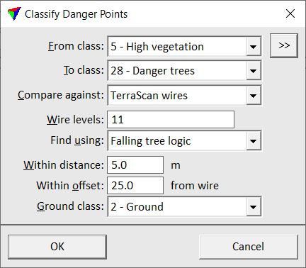
Wire danger points routine classifies points which are within a certain distance from reference elements. The reference elements can be wire elements produced by tools of the Vectorize Wires toolbox or any linear element drawn in the CAD file.
The routine can be used to classify points on potential danger objects along powerlines, rail tracks, roads or other corridor objects. There are three methods how potential danger points are defined:
•Vertical distance to wire - points within a vertical distance from a reference element are classified.
•3D distance to wire - points within a 3D radius around a reference element are classified.
•Falling tree logic - each point is considered as the tip of a tree with its trunk at the xy location of the point and the elevation of the base point on the ground. If the point “falls like a tree” and falls into a 3D buffer area around a reference element, it is classified.
The routine is only available in macros. See Chapter Macros for more information about macro creation and macro actions. However, the routine works similar as the classification part of the Find Danger Objects tool in the View Powerline toolbox.
SETTING |
EFFECT |
|---|---|
From class |
Source class(es). |
|
Opens the Select classes dialog which contains the list of active classes in TerraScan. You can select multiple source classes from the list that are then used in the From class field. |
To class |
Target class. |
Compare against |
Defines the reference elements: TerraScan wires or Any linear elements. |
Wire levels |
CAD file level(s) on which the reference elements are placed. Separate several level numbers by a comma or minus, for example 1-10,13. |
Find using |
Method of danger point definition: Vertical distance to wire, 3D distance to wire, or Falling tree logic. |
Within distance |
Radius that defines a 3D buffer around a reference element. The buffer is added to the reference element for computing distances to points. |
Within offset |
Horizontal distance from a reference element that defines a corridor. Points within the given corridor are analyzed whether they are potential danger points or not. |
Ground class |
Point class with ground points. This is active only if Find using is set to Falling tree logic. |
