

TerraPhoto User Guide
Import files
 Import files command is used to import raw trajectories into TerraScan. During the import, trajectory information is converted into TerraPhoto binary files (*.TRJ).
The input files must contain at least time-stamped position and, for most processing tasks, attitude information. The input files can be:
•text files in one of the implemented ASCII formats.
•binary files from Applanix or Riegl software.
•text files in a user-defined file format, see Trajectory formats.
During the import, the software assigns some attributes to the trajectories and can apply coordinate transformations and/or a time stamp format conversion. Most of the settings defined in the import process can be changed later for the converted trajectory files by using the Edit information command or commands from the Tools pulldown menu.
To import trajectories:
1. Select Import files command from the File pulldown menu.
This opens the Import trajectories dialog, a standard dialog for opening files.
2. Select raw trajectory file(s) and click Done.
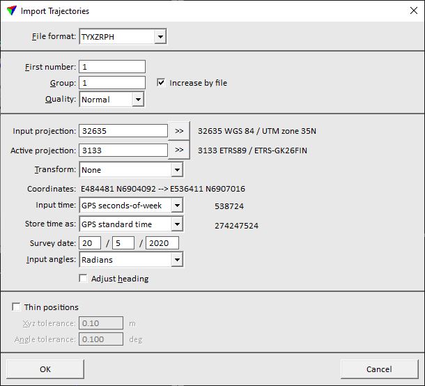
The Import Trajectories dialog opens.
3. Define settings and click OK.
This imports the trajectory file(s) and stores them as TerraPhoto trajectory binary file(s) into the active trajectory directory. The name of a file is determined by the seconds values of the first and last position in a trajectory file separated by an underline character.
SETTING |
EFFECT |
|---|---|
File format |
Format of the raw trajectory file. The software tries to detect it automatically. If a text file is imported, the list of formats contains implemented formats as well as formats defined in Trajectory formats of TerraPhoto Settings. |
Attitude format |
Format of the INS file. This is only active if Merge from GPS and INS command is used to import trajectory information. |
First number |
Number assigned to the first trajectory file. If more than one file is imported, the files are numbered incrementally. |
Group |
Group number assigned to the trajectory file(s). |
Quality |
Quality attribute assigned to the trajectory file(s). |
Input projection |
Projection system of the raw trajectory. Projection systems are defined by their EPSG code. See more information about projection system definition in Coordinate transformations / Transformations. The list also contains projection systems that are defined in Coordinate transformations / User projection systems of TerraPhoto Settings. |
Active projection |
Projection system used for processing the data. The input field works in the same way as the Input projection field. If the Input and Active systems are the same, there is no change in the coordinate values. |
Transform |
Additional transformation applied to the trajectories. The list contains transformations that are defined in Coordinate transformations / Transformations of TerraPhoto Settings. |
Input time |
Format of the time stamps in the raw trajectory file(s): GPS seconds-of-week, GPS standard time, or Unix time. |
Store time as |
Format of the time stamps in the converted trajectory file(s): GPS seconds-of-week or GPS standard time. If the format is different from the Input time format, time stamps are converted. |
Survey date |
Date when the trajectory data was captured. The format is day/month/year (dd/mm/yyyy). This is required for the conversion of time stamps from GPS seconds-of-week to GPS standard time and is only active if Input time and Store time as are set accordingly. |
Input angles |
Format of angle values in the raw trajectory file(s): Degrees, Radians, or TopEye radians. This is usually set automatically for implemented input formats. |
Adjust heading |
If on, the software applies a meridian convergence correction to heading values. The correction is based on the projection system set for WGS84 or the coordinate transformation set for Transform. |
Thin positions |
If on, intermediate trajectory positions are skipped as long as the trajectory accuracy stays within the given tolerances. |
Xyz tolerance |
Maximum allowed xyz difference caused by thinning. This is only active if Thin positions is switched on. |
Angle tolerance |
Maximum allowed angular difference caused by thinning. This is only active if Thin positions is switched on. |
Break at long gaps |
If on, the software splits the trajectory if there is a gap between consecutive trajectory positions that is longer than the given Gap value. The gap value is given in seconds. |
Computing an image list based on trajectory information requires all trajectory positions. Therefore, Thin positions setting should be switched off if camera trajectories are imported.