

TerraPhoto User Guide
Edit information
Edit information command opens a dialog that contains basic information and attributes stored for a selected trajectory. The attributes can be modified. Modifications are immediately stored in the binary trajectory file.
In addition, up to two video files can be linked to a trajectory and a waveform file can be linked to a trajectory. The waveform file settings are not actively used by TerraPhoto but required for the compatibility of trajectories with TerraScan.
To modify trajectory information:
1. Select a trajectory in the list of the Trajectories window.
2. Select Edit information command from the Trajectory pulldown menu.
This opens the Trajectory information dialog:
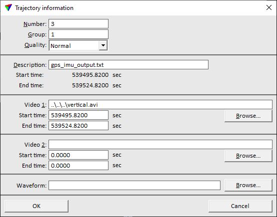
3. Define settings and click OK.
This modifies the information in the header of the corresponding .TRJ file.
SETTING |
EFFECT |
|---|---|
Number |
Number of the trajectory (= line number). |
Group |
Group number of the trajectory. Different groups may be used, for example, to distinguish flight sessions. |
Quality |
Quality attribute of the trajectory. |
Description |
Text that describes the trajectory. By default, the name of the raw trajectory file is used as descriptive text. |
Video 1 |
Primary video file linked to the trajectory. This video is referred to as Vertical video, for example, by Vertical video command. |
Start time |
GPS time stamp of the start position of Video 1. |
End time |
GPS time stamp of the end position of Video 1. |
Video 2 |
Secondary video file linked to the trajectory. This video is referred to as Forward video, for example, by Forward video command. |
Start time |
GPS time stamp of the start position of Video 2. |
End time |
GPS time stamp of the end position of Video 2. |
Waveform |
Waveform data file linked to the trajectory. This is not actively used by TerraPhoto but required for the compatibility of trajectories with TerraScan. |
TerraPhoto requires that you specify both, the start time and the end time of a video file in GPS time stamp format. Normally the end time should be equal to the length of the video file added to the start time. The ability to specify the end time explicitly allows you to compensate for possible inaccuracy of the video clock. The application scales the display speed of the video file in order to cover the given time interval.
If you select several trajectories in the Trajectories window, the Edit information command opens the Edit several trajectories dialog. This dialog allows you to modify only settings which may apply for several trajectories, such as Group and Quality settings.