

TerraModeler User Guide
Statistical model
Statistical model command calculates statistical values based on an existing surface model. It creates a new grid model in the RAM and as surface model file on a hard disk. The new grid model file is saved at the same location where the original surface model is stored.
The new surface is a grid type surface. It contains evenly-spaced points at constant intervals in both, X and Y directions. The statistical values are mathematically derived from the existing surface within a circular or squared calculation area. When calculating a value for a grid point, the application searches for points in the existing model within a given radius from the grid point location. The values in the grid model can represent the number of points; the average, sum, or gravitational sum of elevation values; the minimum or maximum elevation values.
To create a statistical grid model:
1. Select Statistical model command from the Utility pulldown menu.
This opens the Create Balanced Grid Model dialog:
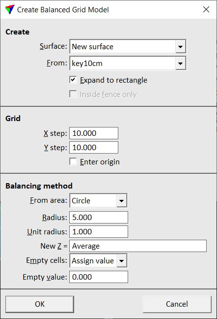
2. Define settings and click OK.
Setting |
Effect |
|---|---|
Surface |
Surface to create. |
From |
Existing surface from which to calculate values. |
Expand to rectangle |
If on, the grid surface is expanded to a rectangular area that encloses the original surface completely. |
Fence contents |
If on, use only points from the original surface that are inside a fence. |
X step |
Interval in X direction between points in the grid model. |
Y step |
Interval in Y direction between points in the grid model. |
Enter origin |
If on, you can enter the origin of the new grid model with a data click. If the data click is located inside the model area, a grid point of the model is placed at the location of the mouse click. |
From area |
Shape of the calculation area around a grid point: •Circle - circle with a given Radius. •Square - square with Radius value equal to half the side length. |
Radius |
Determines the size of the calculation area around a grid point. |
Unit radius |
Radius at which points get a weight factor of 1 when computing the gravitational sum of points. |
New Z |
Mathematical expression to calculate for each grid point inside the calculation area. This may include variables: •Count - the number of points. •Average - the average of elevation values. •Sum - the sum of elevation values. •Gravsum - the gravitational sum of elevation values. •Minimum - smallest elevation value. •Maximum - highest elevation value. |
Empty cells |
Determines how cells without a calculated value are handled in the grid model: •Assign value - a constant value is assigned. •Skip - empty cells are skipped in the model. |
Empty value |
Constant value that is assigned to cells without a calculated value in the grid model. This is only active if Empty cells is set to Assign value. |
This opens the Surface Settings dialog:
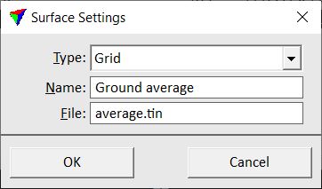
3. Select a Type for the new surface.
4. Define a Name for the grid model.
5. (Optional) Define a new File name for the surface model file stored on the hard disk.
6. Click OK.
This creates a grid model that represents the derived statistical values of the original surface model.