

TerraScan User Guide
Import files
Import files command is used to import raw trajectories into TerraScan. During the import, trajectory information is converted into TerraScan trajectory binary files (*.TRJ).
The input files must contain at least time-stamped position and, for most processing tasks, attitude information. The input files can be:
•text files in one of the implemented ASCII formats, see Supported file formats
•binary files from Applanix or Riegl software, see Supported file formats
•text files in a user-defined file format, see File formats / User trajectory formats
During the import, the software assigns some attributes to the trajectories and can apply coordinate transformations and/or a time stamp format conversion. Most of the settings defined in the import process can be changed later for the converted trajectory files by using the Edit information command or commands from the Tools pulldown menu.
If external accuracy files are available for Riegl POF (*.POQ) and Applanix SBET.OUT (SMRMSG_*.OUT) trajectory formats, the command reads the information automatically from the files matching the trajectory files. In this case, Import accuracy files is no longer necessary in a separate step.
To import a raw trajectory:
1. Select Import trajectories command from the File pulldown menu.
This opens the Import trajectories dialog, a standard dialog for opening files.
2. Select the raw trajectory file(s) and click Open.
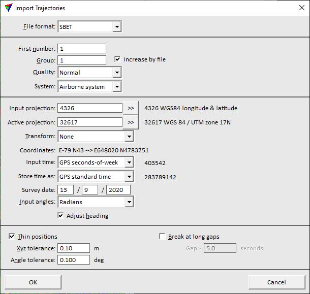
The Import Trajectories dialog opens:
3. Define settings and click OK.
This imports the trajectory file(s) and stores them as TerraScan trajectory binary file(s) into the active trajectory directory. The name of a file is determined by the start time (and end time if GPS seconds-of-week) of a trajectory using 0.01 second resolution. The parts in the file name are separated by underline characters.
SETTING |
EFFECT |
|---|---|
File format |
File format of the input file(s). This is usually recognized automatically for implemented input formats. |
Attitude format |
Format of the INS file. This is active only if Merge from GPS and INS command is used to import trajectory information. |
First number |
Number assigned to the first trajectory file. If more than one file is imported, the files are numbered incrementally. |
Group |
Group number assigned to trajectory file(s). Groups may indicate, for example, different flight sessions and can be used by TerraMatch processes. |
Increase by file |
If on, the group number is automatically increased for each imported trajectory file. |
Quality |
Quality attribute assigned to trajectory file(s). Quality may indicate, for example, the accuracy of trajectories and can be used for TerraMatch and TerraScan processes. |
System |
Scanner system used for data collection. This may add lever arm corrections to trajectory positions and thus, effect the computation of the scanner location at the moment of measuring a laser point. |
Input projection |
Projection system of the input data. Click on the >> Button to open the Browse for Projection System dialog. The dialog provides a search option for projection systems as well as a list of all implemented systems. In addition, any user-defined projection systems are included in the list. |
Active projection |
Projection system of the data for processing. Click on the >> Button to open the Browse for Projection System dialog. The dialog provides a search option for projection systems as well as a list of all implemented systems. In addition, any user-defined projection systems are included in the list. |
Transform |
Additional transformation applied to points during the reading process. The list contains transformations that are defined in Coordinate transformations / Transformations category of TerraScan Settings. |
Coordinates |
Easting and Northing coordinate values of the first point found in the point cloud. The first values are coordinates in the Input projection system, the second values in the Active projection system or after an additional transformation has been applied. If the values are the same, no transformation is applied. |
Input time |
Format of time stamps in the raw trajectory file(s): GPS seconds-of-week, GPS standard time, Unix time, or GPS time. |
Store time as |
Format of time stamps in the converted files: GPS seconds-of-week, GPS standard time, or GPS time. If the format is different from the Input time format, time stamps are converted. |
Survey date |
Date when the trajectory data was captured. The format is day/month/year (dd/mm/yyyy). This is required for the conversion of time stamps from GPS seconds-of-week to GPS standard time and is only active if Input time and Store time as are set accordingly. |
Input angles |
Format of angle values in the raw trajectory file(s): Degrees, Radians, or TopEye radians. This is usually set automatically for implemented input formats. |
Adjust heading |
If on, the software applies a meridian convergence correction to heading values. The correction is applied if there is a projection system change from WGS 84 longitude/latitude coordinates to another system. |
Thin positions |
If on, intermediate positions are skipped as long as the trajectory accuracy stays within the given tolerances. |
Xyz tolerance |
Maximum allowed locational change of the trajectory caused by thinning. This is active only if Thin positions is switched on. |
Angle tolerance |
Maximum allowed angular change of the trajectory caused by thinning. This is active only if Thin positions is switched on. |
Break at long gaps |
If on, the software splits the trajectory if there is a gap between consecutive trajectory positions that is longer than the given Gap value. The gap value is given in seconds. |
TerraScan and TerraMatch do not need highly accurate trajectory information. It is beneficial to remove unnecessary positions with Thin positions setting when importing a raw trajectory. This reduces the amount of memory consumed by trajectory information and speeds up processes.