

TerraScan User Guide
Import scanner positions
Import scanner positions command is used to import positions of tripod-mounted scanners into TerraScan. The scanner positions must be stored in space-delimited text files of the format:
•number easting northing elevation
The number of a scanner position must be a numerical value, no alphanumerical or other characters are allowed. During the import, the software assigns some attributes to the scanner positions and can apply coordinate transformations. Most of the settings defined in the import process can be changed later for the converted trajectory files by using the Edit information command or commands from the Tools pulldown menu.
To import scanner positions from a text file:
1. Select Import scanner positions command from the File pulldown menu.
This opens the Import scanner positions dialog, a standard dialog for selecting files.
2. Select the text file and click Done.
The Import Scanner Positions dialog opens:
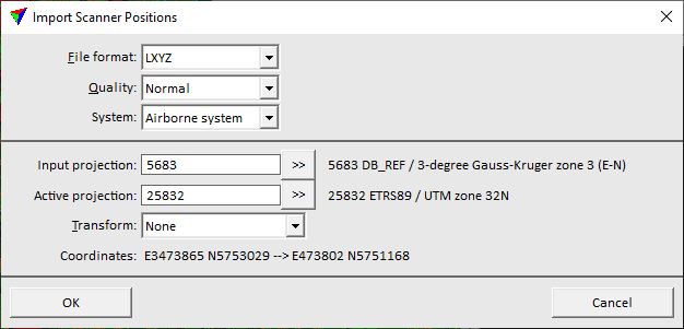
3. Define settings and click OK.
This imports the text file and stores the scanner positions as TerraScan trajectory binary file(s) into the active trajectory directory. The name of a file is determined by the position number.
SETTING |
EFFECT |
|---|---|
File format |
File format of the input file. This is usually recognized automatically for implemented input formats. |
Quality |
Quality attribute assigned to trajectory file(s). Quality may indicate, for example, the accuracy of trajectories and can be used for TerraMatch and TerraScan processes. |
System |
Scanner system used for data collection. This may add lever arm corrections to trajectory positions and thus, effect the computation of the scanner location at the moment of measuring a laser point. Scanner systems are defined in the corresponding category of TerraScan settings. |
Input projection |
Projection system of the input data. Click on the >> Button to open the Browse for Projection System dialog. The dialog provides a search option for projection systems as well as a list of all implemented systems. In addition, any user-defined projection systems are included in the list. |
Active projection |
Projection system of the data for processing. Click on the >> Button to open the Browse for Projection System dialog. The dialog provides a search option for projection systems as well as a list of all implemented systems. In addition, any user-defined projection systems are included in the list. |
Transform |
Additional transformation applied during the import. The list contains transformations defined in Coordinate transformations / Transformations category of TerraScan Settings. |