

TerraScan User Guide
Edit information
Edit information command opens a dialog that contains basic information and attributes stored for a selected trajectory. The attributes can be modified. Modifications are immediately stored in the binary trajectory file.
In addition, up to two video files and a waveform file can be linked to a trajectory. The video file settings are not actively used by TerraScan but required for the compatibility of trajectories with TerraPhoto.
The Waveform field may contain a link to a single waveform file, for example, if one LAS or WDP file contains data of one line (trajectory). Alternatively, a file name with wild-cards can be used to establish a link between one trajectory and several waveform files. Example: "Laser_20160308_*.las" or "Laser_20160308_FL??_???.las" can be used to link waveform files with names "Laser_20160308_FL20_123.las" and "Laser_20160308_FL21_124.las" to one trajectory.
In order to link a waveform file to a trajectory, select the LAS file even if the waveform data is stored in WDP files. Only one file name in the field is allowed. If several waveform files need to be linked, select one file and then, replace the varying part(s) of the file name with wild-cards. If waveform files are linked in the Trajectory information dialog, no index files for waveform files are created.
TerraScan Lite and TerraScan UAV do not provide any waveform processing capabilities.
To modify trajectory information:
1. Select a trajectory in the list of the Trajectories window.
2. Select Edit information command from the Trajectory pulldown menu.
This opens the Trajectory information dialog:
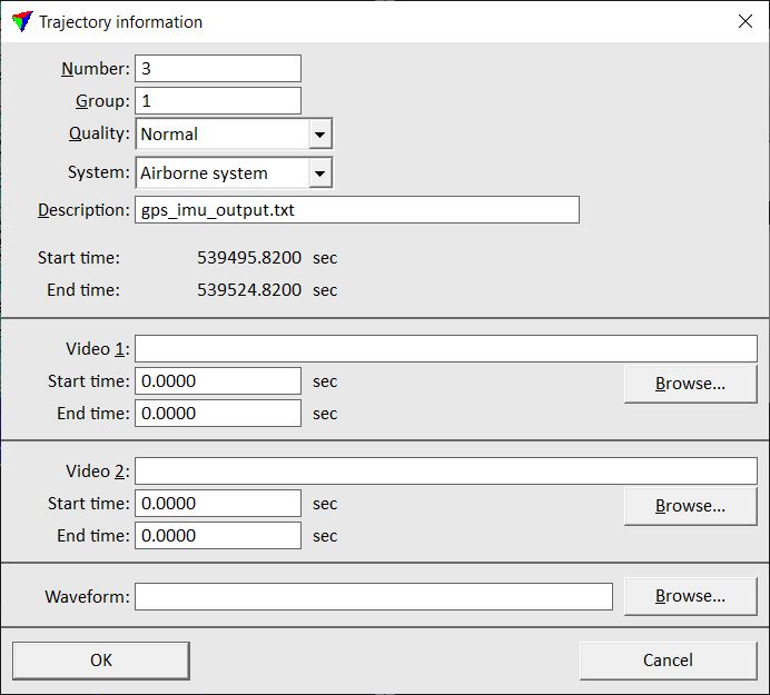
3. Define settings and click OK.
This modifies the information in the header of the corresponding .TRJ file.
SETTING |
EFFECT |
|---|---|
Number |
Number of the trajectory. |
Group |
Group number of the trajectory. Group numbers may indicate, for example, different flight sessions and are used for TerraMatch processes. |
Quality |
Quality attribute of the trajectory. Quality may indicate, for example, the accuracy of trajectories and can be used for TerraMatch and TerraScan processes. |
System |
Scanner system used for data collection. This determines lever arm corrections that are added to trajectory positions and thus, effects the computation of the scanner location at the moment of measuring a laser point. |
Description |
Text that describes the trajectory. By default, the name of the raw trajectory file is used as descriptive text. |
Video 1 |
Primary video file linked to the trajectory. This is not actively used by TerraScan but required for the compatibility of trajectories with TerraPhoto. |
Start time |
GPS time stamp of the start position of Video 1. |
End time |
GPS time stamp of the end position of Video 1. |
Video 2 |
Secondary video file linked to the trajectory. This is not actively used by TerraScan but required for the compatibility of trajectories with TerraPhoto. |
Start time |
GPS time stamp of the start position of Video 2. |
End time |
GPS time stamp of the end position of Video 2. |
Waveform |
Waveform data file linked to the trajectory. See Link to waveform files command and Chapter Waveform Processing for more information. |
If you select several trajectories in the Trajectories window, the Edit information command opens the Edit several trajectories dialog. This dialog allows you to modify only settings which may apply for several trajectories, such as Group, Quality, and System settings.