

TerraScan User Guide
Label Catenary Height
 Label Catenary Height tool labels the location of the minimum elevation difference between a catenary element and laser points loaded in TerraScan.
It finds the lowest point of a catenary element, derives an elevation value from all points within a given radius around this XY location. Then, it computes the elevation difference between the catenary and the derived elevation value. The tool draws a vertical line that marks the lowest catenary point. In addition, a text element is drawn that shows the elevation difference value. The text is drawn using the active text, level, and symbology settings of the CAD file.
To label height from catenary to ground:
1. Select the Label Catenary Height tool.
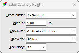
This opens the Label Catenary Height dialog:
2. Define settings.
3. Select a catenary string element with a data click.
The catenary is highlighted.
4. Accept the selected catenary element with another data click inside the view.
The location of minimum height difference is labeled. You can continue with step 3.
OR
1. Select catenary string element(s) to label
2. Select the Label Catenary Height tool.
3. Accept the selected catenary element(s) with a data click inside the view.
The location(s) of minimum height difference(s) is labeled.
SETTING |
EFFECT |
|---|---|
From class |
Point class used for the elevation difference computation. |
Within |
Radius within which points are used for computing the elevation value. |
Compute |
Clearance computation logic: •Vertical difference - direct vertical clearance •3D distance - direct distance between the catenary and the point cloud |
Draw As |
Height labeling method: •Vertical line - vertical line between the catenary and the point cloud •3D line - direct line between the catenary and the closest point |
Accuracy |
Number of decimals for drawing the label. |