

TerraScan User Guide
Assign Point Class
 Assign Point Class tool classifies a single laser point or points that belong to a group of points. It classifies either the closest point to the data click, or the highest or lowest point within a circular search area. For group classification, the point selection method determines which group is classified.
Classifying points of a group requires the assignment of group numbers to laser points. This can be done by using the Assign groups commands for loaded points or the corresponding macro actions for macro processing of project blocks.
The tool works in top views as well as in section views or any rotated views.
To classify a single point or a group of points:
1. Select the Assign Point Class tool.
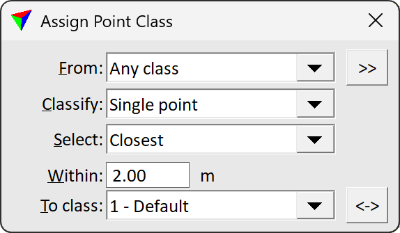
The Assign Point Class dialog opens:
2. Define settings.
3. Move the mouse pointer inside a view.
In a top view, the search area is shown at the mouse pointer position.
4. Identify the single point or the group of points with a data click.
This classifies the identified point or point group. You can continue with step 2 if you want to change settings, or with step 3.
5. Use Save points or Save points As commands in order to save changes to point classes permanently into a laser point file.
SETTING |
EFFECT |
|---|---|
From |
Source class; only points from this class are affected. The list contains the active classes in TerraScan. Alternatively, Any visible point can be classified. |
|
Opens the Select classes dialog which contains the list of active classes in TerraScan. You can select multiple source classes from the list that are then used in the From class field. |
Classify |
Defines which points are classified: Single point or Whole group. Whole group is only active if group numbers are assigned to laser points. |
Select |
Method how the software selects a point or group for classification: •Closest - the point closest to the data click is classified. •Highest - the highest point within the search area is classified. •Lowest - the lowest point within the search area is classified. |
Within |
Radius of the search area. Given in master units of the CAD file. |
To class |
Target class into which points are classified. The list contains the active classes in TerraScan. |
|
Switches From and To class classes. If From class is set to multiple classes or Any visible point, To class is switched to the source class with the lowest class number. |

