

TerraScan User Guide
Add Synthetic Point
 Add Synthetic Point tool adds synthetic points to a point data set loaded in TerraScan. It may be used to create single points, points along selected vector elements or inside selected polygons.
If a single point is added in a top view, its xy location is determined by the data click position and its elevation is fixed to the active Z setting in the CAD file. If a point is added in a section view, its xy location is fixed to the center of the section and its elevation is set by the data click position.
Points along a vector element are created at the exact 3D position of the element and with a given spacing between the points.
Points inside a polygon are created as grid with a given horizontal point distance. The elevation can be determined in different ways, such as a key-in value, the mouse pointer position, derived from other point classes or from the polygon elevation.
To add synthetic points:
1. Select vector elements or polygons if you want to add points along or inside them.
2. Select the Add Synthetic Point tool.
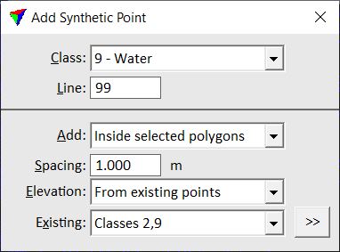
The Add Synthetic Point dialog opens:
3. Define settings.
4. Place a single synthetic point with a data click in a view.
This adds a new point to the loaded point data set. You can continue with step 2 if you want to change settings, or with step 3.
OR
4. Confirm selected vector elements or polygons with a data click inside the CAD view. If Elevation is set to From mouse click, place a data click inside a section view in order to determine the elevation value for the new points.
This adds the new points to the loaded point data set.
5. Use Save points or Save points As commands in order to save added points permanently into a laser point file.
SETTING |
EFFECT |
|---|---|
Class |
Target class into which synthetic points are added. The list contains the active classes in TerraScan. |
Line |
Line number assigned to synthetic points. |
Add |
Method of adding new points: •Single point - a single point is added by a data click. •Along selected vectors - points are added along selected vector elements. •Inside selected polygons - points are added inside selected polygons. |
Spacing |
Distance between new points along an element or inside a polygon. This is active only if Add is set to Along selected vectors or Inside selected polygons. |
Elevation |
Method of how the elevation of new points inside a polygon is computed: •From existing points - points in given Existing class(es) are used. The >> button opens the Select Classes dialog which lets you select several classes. •From polygons - the average elevation of a polygon is used for the points falling inside the polygon. •From mouse click - a data click in a section view determines the elevation of the new points. •As keyin value - the given Keyin Z value is used. This is active only if Add is set to Inside selected polygons. |