

TerraScan User Guide
Rotate
Rotate command lets you rotate a point cloud interactively. The point cloud is rotated around a center point and only in horizontal direction.
To rotate a point cloud:
1. Select Rotate command from the Measurement pulldown menu.
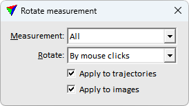
This opens the Rotate measurement dialog:
2. Define settings.
3. Place a data click inside a view in order to define the center point of the rotation.
If the mouse pointer is moved, a temporary line illustrates the base line for the rotation.
4. Place another data click inside the view in order to define the origin point of the rotation (= end point of the base line).
If the mouse pointer is moved, a temporary line illustrates the direction and angle of the rotation.
5. Place another data click inside the view in order to define the destination point of the rotation (= rotation direction and angle).
This rotates the point cloud to the new position.
SETTING |
EFFECT |
|---|---|
Measurement |
Points that are effected by the rotation: points from all scans or only from one specific scan. The list contains all scan numbers that are available in the loaded point cloud. |
Rotate |
Rotation method: •By mouse clicks - source and target points for computing the transformation are defined manually. No additional settings are required for this method. •By normal vectors - rotate the cloud to make the dominant normal vector direction point up. •90 deg clockwise - 90 degrees around vertical axis in clockwise direction. Sample center defines the rotation center point. •180 deg - 180 degrees around vertical axis. Sample center defines the rotation center point. •90 deg counter clockwise - 90 degrees around vertical axis in counter clockwise direction. Sample center defines the rotation center point. |
Apply to trajectories |
If on, the rotation is applied to active trajectories / scanner positions. |
Apply to images |
If on, the rotation is applied to the loaded image list. |