

TerraScan User Guide
Transform coordinates
Not UAV
Transform coordinates command applies a coordinate transformation to the block binary files and/or block boundaries.
The command can use the following transformation types:
•Dz - fixed elevation difference value in order to apply a systematic elevation shift.
•Dxyz - text file storing difference values for easting, northing and elevation. The format of the text file is X Y dX dY dZ.
•Projection change - from one implemented projection system to another.
•A specific transformation defined in Coordinate transformations / Transformations category of TerraScan Settings.
To transform block boundaries:
1. Select Transform coordinates command from the Tools pulldown menu.
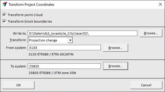
This opens the Transform Project Coordinates dialog:
2. Define settings and click OK.
This opens the Target Coordinate Setup dialog.
3. Define a coordinate setup for the new project and click OK.
This transforms the coordinates of block boundaries and/or the point cloud. The process writes a new project file and new block binary files in the given output folder. After the process is finished, a report shows the number of transformed points for each block binary file.
SETTING |
EFFECT |
|---|---|
Transform point cloud |
If on, the block binary files are transformed and stored in (new) files. |
Transform block boundaries |
If on, block boundaries are transformed and stored in a (new) project file. |
Write to |
Output folder for the transformed project and block binary files. If the folder contains already files with the same name, they are overwritten. |
Transform |
Type of transformation to be applied: •Dz - fixed elevation difference value in order to apply a systematic elevation shift. •Dxyz - text file storing difference values for easting, northing and elevation. The format of the text file is X Y dX dY dZ. •Projection change - from one implemented projection system to another. •<name> - name of a transformation defined in Coordinate transformations / Transformations category of TerraScan Settings. |
Dz |
Value added to the elevation coordinate of each point. This is active only if Transform is set to Dz. |
Dxyz |
Text file that stores the XYZ correction values. This is active only if Transform is set to Dxyz. |
From system |
Source projection system. The software shows the system information if it is stored in the project definition. To change the projection system, click on the Browse button. This opens the Browse for Projection System dialog. The dialog provides a search option for projection systems as well as a list of all implemented systems. In addition, any user-defined projection systems are included in the list. This is active only if Transform is set to Projection change. |
To system |
Target projection system. Click on the Browse button to open the Browse for Projection System dialog. The dialog provides a search option for projection systems as well as a list of all implemented systems. In addition, any user-defined projection systems are included in the list. This is active only if Transform is set to Projection change. |
You may use Draw boundaries command to draw the transformed boundaries into the CAD file.