

TerraScan User Guide
Output collections
Not UAV
Collection shapes can be used to produce output files where logical groups of points are put together. You can perform the grouping by placing collections shapes around the objects using the Place Collection Shape tool. The output process starts from the Project window and automatically gathers all necessary points from the block binary files.
The output files can be created in two ways:
•The points inside each collection shapes are written into a separate output file. The name of the output files are determined by an optional prefix and either the number of the collection shape or an automatically increasing number.
•All points inside collection shapes are written into one output file.
The output file format should be a user-defined text file format which includes a Collection field so that points belonging to different collections can be distinguished from each other. See File formats / User point formats category of TerraScan Settings for more information. However, any text file format or TerraScan binary format is a valid output format for point collections.
To output collection shapes:
1. Select Output collections command from the Tools pulldown menu.
This opens the Output Collections dialog:
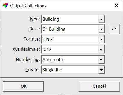
2. Define settings and click OK.
3. If Create is set to Single file, the software opens the Collection output file dialog, a standard dialog for saving files. Define a location, name, and extension for the output file and click Save.
This starts the output process.
SETTING |
EFFECT |
|---|---|
Type |
Collection shape type to output. The list contains all collection shape types that are defined in Collection shapes category of TerraScan Settings. |
Class |
Point class(es) to output. |
|
Opens the Select classes dialog which contains the list of active classes in TerraScan. You can select multiple source classes from the list that are then used in the Class field. |
Format |
Output file format. |
Xyz decimals |
Number of decimals used for coordinate values in the output files. This is active only if a text file format is chosen as output format. |
Numbering |
Defines the number of a point collection and the numbering method for naming separate output files: •Automatic - automatically increasing numbers starting from 1. •From texts - text elements drawn inside collection shapes. |
Create |
Defines the output: Single file or One for each shape. |
Directory |
Directory for storing output files. This is active only if Create is set to One for each shape. |
Prefix |
Defines the first part of the output file names which is followed by a number. This is active only if Create is set to One for each shape. |
Extension |
File name extension. Allowed extensions are .TXT or .ASC for text files and .BIN for TerraScan Binary files. This is active only if Create is set to One for each shape. |
