

TerraScan User Guide
Extract color from images
Not UAV
Extract color from images command extracts RGB color values from raster images and assigns the color values to laser points in block binary files. The color sources can be orthophotos attached as TerraPhoto raster references or raw images in an active TerraPhoto image list. In addition, a color point file can be used to balance colors of the raw images before the color values are assigned to the laser points. The command requires TerraPhoto or TerraPhoto Lite running on the same computer.
TerraScan can extract up to 10 color channels for each point. The maximum amount of color channels can only be stored in the TerraScan FastBinary format. LAS 1.4 format and later can store up to 4 color channels, LAS 1.2 format and later and TerraScan Binary files up to 3.
The color for a laser point is derived by resampling the color values of all the pixels inside a circular area around the point. There are different methods of color value extraction from raw images which are either suitable for airborne or mobile data sets.
The process can involve the computation and storage of image numbers. The number of the image used for extracting the color can be stored for each laser point. This requires the storage of points in TerraScan FastBinary format. The image number stored as laser point attribute is required for advanced coloring methods for mobile point clouds.
The command performs the same action on block binary files as the Extract color from images command on loaded points.
To extract color from attached orthophotos or raw images:
1. Attach reference images in TerraPhoto’s Manage Raster References tool.
OR
1. Load an image list into TerraPhoto.
2. Select Extract color from images command from the Tools pulldown menu.
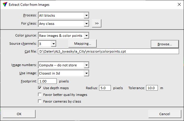
This opens the Extract Color from Images dialog:
3. Define settings and click OK.
This derives color values for the laser points from the defined source images.
SETTING |
EFFECT |
|---|---|
Process |
Blocks to process: All blocks or Selected blocks. |
For class |
Laser point class(es) for which colors are extracted. |
|
Opens the Select classes dialog which contains the list of active classes in TerraScan. You can select multiple source classes from the list that are then used in the For class field. |
Color source |
Source files for color extraction: •Ortho images - colors are extracted from attached TerraPhoto raster references. •Raw images - colors are extracted from raw images in an active image list in TerraPhoto. •Raw images & color points - colors are extracted from raw images and from a color point file. |
Source channels |
Amount of color channels to be extracted. Click on the Mapping button in order to set the channel numbers for color extraction in the Extract Color Channel Mapping dialog. This makes it possible extract RGB channels from one set of images and NIR channel from another set of images (other channels can be skipped). |
Cpt file |
Location and name of a color point file. This is active only if Color source is set to Raw images & color points. |
Balance using intensity |
If on, mitigates shadows in colorization by balancing image brightness with laser intensity represented in Intensity, Reflectance, or Amplitude within the neighborhood Radius for each point. |
Image numbers |
Method how the software handles the computation and storage of image numbers from raw images: •Compute -- do not store - image numbers are computed but not stored for laser points. •Compute and store - image numbers are computed and each laser point stores the number of the image from which it gets the color. •Use stored - stored image numbers of laser points are used for color extraction. |
Use image |
Method how the software determines the raw image for extracting a color for a laser point: •Closest in 3d - closest camera XYZ position. Optimized for airborne data sets. •Closest in xy - closest camera XY position. Optimized for airborne data sets. •Closest in time - closest time stamp. Optimized for airborne data sets. •Mobile -- closest in time - closest time stamp. Optimized for mobile data sets. •Mobile -- ground surface - best ground surface visibility. Optimized for mobile data sets. •Mobile -- closest in 3d - closest camera XYZ position. Optimized for mobile data sets. |
Footprint |
Radius of a circular area around each laser point within which pixel color values are resampled. Given in meters for a method optimized for airborne data sets and in pixels for mobile data sets. This is the only active if Color source is set to Ortho images. |
Max distance |
Maximum distance between a raw image and a laser point. Images outside that distance are not considered for color extraction. This is active only if Use image is set to any method optimized for mobile data sets. |
Max time diff |
Maximum time difference between a raw image and a laser point. Images outside that difference are not considered for color extraction. This is active only if Use image is set to Mobile -- closest in time. |
Use depth maps |
If on, depth maps files are included in the color extraction process. See TerraPhoto User Guide for more information about depth maps. |
Radius |
Radius checked in image depth maps to find out if the point is visible in the image or occluded. |
Tolerance |
Allowed depth difference between a point and depth map before the point is considered occluded. If the depth of a point is bigger than depth map value and tolerance together, point in that image is considered occluded and some other image is used in color extraction. |
Favor better quality images |
If on, the quality attribute stored for raw images in an image list is considered in the color extraction process. See TerraPhoto User Guide for more information about the quality attribute. |
Favor cameras by class |
If on, the settings in the TerraPhoto mission file related to favoring cameras for coloring points are considered in the color extraction process. See TerraPhoto User Guide for more information about the mission definition. |
