

TerraScan User Guide
Export to Google Maps
Not UAV
Export to Google Maps command creates a KML file that includes the block boundaries and links to block binary files of the project. With the help of this file, a point cloud project can be published in Google Maps. The following steps are required:
1. (Recommended) The storage format of the block binary files should be LAZ. Use the Convert storage format command in order to convert files to LAZ.
2. Upload the block binary files to any data exchange platform that is publicly available.
3. Export the project into a KML file as described below.
4. In you Google Maps account, create a new map by defining a title and description.
5. Import the KML file created in step 3.
The block boundaries are added as new layer to the map. Each block polygon acts as a link to the LAZ file on the data exchange platform. By clicking inside a block polygon, the download of the corresponding block binary file starts. Alternatively, the user can download all block binary files.
The download of the files can be password protected by options of the data exchange platform.
To export a project into a KML file:
1. Select Export to Google Maps command from the Tools pulldown menu.
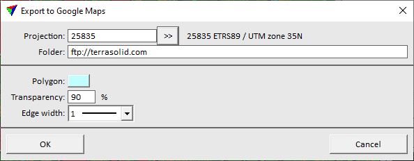
This opens the Export to Google Maps dialog:
3. Define settings and click OK.
The KML output file dialog opens, a standard dialog for saving files.
5. Define a location and name for the KML file and click Save.
The software creates the KML file.
SETTING |
EFFECT |
|---|---|
Projection |
Projection system of the project data. The software shows the system information if it is stored in the project definition. To change the projection system, click on the >> button. This opens the Browse for Projection System dialog. The dialog provides a search option for projection systems as well as a list of all implemented systems. In addition, any user-defined projection systems are included in the list. |
Folder |
Folder for storing the block binary files on a data exchange platform. The folder must be publicly available but file download may be password protected. |
Polygon |
Line/filling color of the block polygons in Google Maps. Click on the color button in order to open the Windows dialog for selecting a color. |
Transparency |
Transparency percentage for displaying the block polygons in Google maps. The higher the value, the more the background map is visible. |
Edge width |
Line width of the block boundary in Google Maps. The list contains the standard line widths of the CAD platform. |