

TerraScan User Guide
Adjust to geoid
Adjust to geoid command adjusts the elevation values of a point cloud to a local elevation model. The elevation model can be defined by an implemented geoid model, a text file, a TerraModeler surface or a selected linear chain.
The theory of geoid adjustment and the use of the command in TerraScan are explained in detail in section Geoid adjustment.
To run elevation adjustment on loaded points:
1. Choose Adjust to geoid command from the Tools pulldown menu.
This opens the Adjust to Geoid dialog:
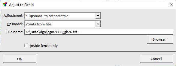
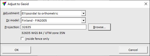
2. Define settings and click OK.
This starts the geoid adjustment for the loaded points. When the process has finished, an information dialog shows the number of adjusted points and the variation of adjustment values.
SETTING |
EFFECT |
|---|---|
Adjustment |
Direction of the elevation adjustment: •Ellipsoidal to orthometric - adjustment from ellipsoidal to orthometric height values. This is the normal way of an geoid adjustment. •Orthometric to ellipsoidal - adjustment from orthometric to ellipsoidal height values. This is the reverse way of an geoid adjustment. |
Dz model |
Source file that provides the geoid correction model: •Points from file - space separated X Y dZ text file as described in Introduction to geoid adjustment. •ISG geoid file - a geoid file in isg format. •Selected linear chain - linear element selected in the CAD file. •<name> - name of a geoid model loaded as surface in TerraModeler. •<implemented model> - name of an implemented geoid model. |
File name |
Name of the geoid text file. This is active only if Dz model is set to Points from file. |
Extend |
Distance from a selected linear element by which the linear chain is extended for elevation value corrections. This is active only if Dz model is set to Selected linear chain. |
Inside fence only |
If on, geoid adjustment effects only loaded points that are located inside a fence or selected polygon. Requires a fence or selected polygon in the CAD file. |
Projection |
The active projection system of the point cloud data. This is active only if Dz model is set to any implemented geoid model. |