

TerraScan User Guide
Add point to ground
Add point to ground command lets you classify points inside a certain area to the ground class. This may be useful to correct classification errors effectively in areas where the automatic ground classification does not provide a good result.
The command is used most likely after an automatic Ground classification has been performed. It classifies additional points to the ground class based on an initial point and additional settings defined in the command’s settings dialog. The source class from which the points are added to ground has to be visible in the view in which the classification is started.
To add points to the ground:
1. Select Add point to ground command from the Classify pulldown menu.
This opens the Add Point to Ground dialog:
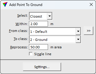
2. Define settings for the search for additional ground points.
SETTING |
EFFECT |
|---|---|
Select |
Defines which point is selected as initial point for the ground classification: •Closest - the point closest to the data click within the search radius. •Highest - the highest point within the search radius. •Lowest - the lowest point within the search radius. |
Within |
Search radius around the mouse click to find the initial point for starting the ground classification. |
From class |
Source class from which points are classified into ground. |
|
Opens the Select classes dialog which contains the list of active classes in TerraScan. You can select multiple source classes from the list that are then used in the From class field. |
To class |
Target class for classified ground points. |
Reprocess |
Area within which points are classified. The value defines the radius of a circular area around the initial point. |
Single line |
If on, only points from one line at a time are classified. This may result in ground levels per line. |

3. (Optional) Click on the Settings button in order to change settings for the ground detection parameters.
This opens the Ground Processing Settings dialog:
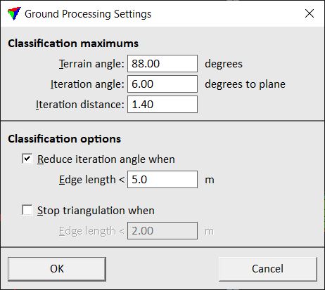
The settings are the same as for the automatic ground classification. See Ground classification routine for a detailed description of the settings.
Apply the settings by clicking OK.
4. Click inside a view to define the initial location for adding ground points.
This classifies visible points from the source class to the ground class according to the given settings and within the defined reprocessing area.