

TerraScan User Guide
Detect plane
Not Lite
Detect plane command detects points on a plane inside a fence or selected polygon from one point class. It classifies the points into another class and optionally draws a 3D rectangle around the points on the plane.
The tool works only in top views. It does not detect close-to-vertical or vertical planes.
To detect a plane from laser points:
1. Draw a fence or select a polygon around the area where the plane(s) are located.
2. Select Detect plane command from the Classify pulldown menu.
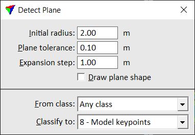
This opens the Detect Plane dialog:
3. Define settings.
4. Click inside the fence to define a start point for the plane detection.
The software highlights points that are found on a plane. In addition, the angle of the plane and the time spent for plane detection is shown in the message center at the bottom of the CAD platform interface.
5. Accept the points with another data click.
This classifies the points on the plane and (optionally) draws a rectangle around the plane. The rectangle element is drawn on the active level using the active symbology settings of the CAD file.
SETTING |
EFFECT |
|---|---|
Initial radius |
Start radius for plane detection. |
Plane tolerance |
Defines the distance how close points must match a fitted plane equation. |
Expansion step |
Maximum gap between points belonging to the same plane. |
Draw plane shape |
If on, a 3D rectangle is drawn around the points on the detected plane. |
From class |
Source class from which points are used for plane detection. |
Classify to |
Target class for points on the detected plane. |