

TerraScan User Guide
Measure Coverage
 Measure Point Density tool computes the area of selected polygons that is covered by the point cloud. This may include only selected point classes which represent certain feature types, such as trees, buildings, etc.. The tool generates a report that shows for each polygon the size of the whole area and the covered area as percentage value.
In addition, the tool places a text element inside each polygon. The text element shows the percentage of covered area. It is drawn with the active symbology and text settings of the CAD file.
To measure the coverage:
1. Select one or more polygons for which you want to measure the point cloud coverage.
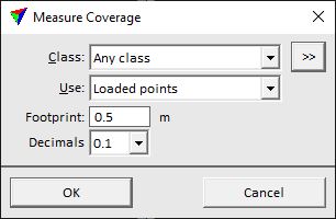
2. Select the Measure Coverage tool.
This opens the Measure Coverage dialog:
3. Define settings and click OK.
This computes the coverage, displays the report window and draws the text element(s) into the CAD file. You can save the report as text file or print it directly by using the commands from the File menu of the report window.
SETTING |
EFFECT |
|---|---|
Class |
The point coverage is computed for points of any class or of a specific class. The list contains the active class definitions in TerraScan. |
|
Opens the Select classes dialog which contains the list of active classes in TerraScan. You can select multiple source classes from the list that are then used in the Class field. |
Use |
Defines which points are used for the coverage measurement: •Loaded points - coverage is computed from points loaded in TerraScan. •Project points - coverage is computed from binary files referenced by the active project in TerraScan. Not UAV |
Footprint |
Diameter of a circular area that is covered by each point. Basis for computing the coverage. The value should be big enough that gaps caused by normal scan pattern are closed. |
Decimals |
Number of decimals for labeling the point coverage inside polygons. Up to 2 decimals can be used. |
