

TerraScan User Guide
Mark Polygons by Points
 Mark Polygons by Points tool identifies polygons bounding laser data fulfilling defined criteria. A polygon is defined as inside if its centroid is within the boundaries of the bounding polygon. The polygons matching the defined criteria are modified with active actions.
To mark polygons by points:
1. Select the polygon(s).
2. Select the Mark Polygons by Points tool.
The Mark Polygons by Points dialog opens:
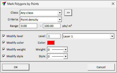
3. Define settings.
4. Place a data click inside a view.
This modifies the polygons if points bounded by the polygon fulfill the selected criteria.
SETTING |
EFFECT |
|---|---|
Class |
Point class(es) used to evaluate polygons |
Criteria |
The criteria applied to pick polygons: •Presence of points - if any points inside polygon. •Point density - if point density inside polygon within range. •Average amplitude - average amplitude attribute value of points.. •Average brightness - average color brightness value of points. •Average intensity - average intensity attribute value of points. •Average reflectance - average reflectance attribute value of points. •Smallest distance - smallest distance attribute value of points. •Average distance - average distance attribute value of points. •Biggest distance - biggest distance attribute value of points. |
Range |
Value range required for the selected criteria |
Level |
If on, defines the level to which selected elements fulfilling the criteria are moved. |
Color |
If on, defines the active color applied to selected elements fulfilling the criteria. |
Weight |
If on, defines the weight applied to selected elements fulfilling the criteria. |
Style |
If on, defines the style applied to selected elements fulfilling the criteria. |