

TerraScan User Guide
Mouse Point Adjustment
 Mouse Point Adjustment tool adjusts vector data to the location and/or the elevation of laser points. You can use this tool with any CAD or TerraScan element placement tool. Mouse Point Adjustment simply fixes the coordinates of data clicks, which means the vertices of vector elements to laser data coordinates. It might be considered as a “snap to laser points” tool.
You can choose whether the elevation and/or the xy location of the vertices are adjusted. If you want to digitize a linear object, such as a wire, you probably want to adjust both, the xy and the elevation of the vertices to the laser points. On the other hand, if you want to place an object on the ground, you probably want to adjust only the elevation of the vertices.
To place elements adjusted to laser points:
1. Select the Mouse Point Adjustment tool.
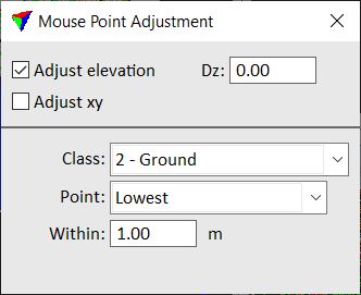
This opens the Mouse Point Adjustment dialog:
2. Define setting.
3. Start the drawing tool that you want to use and digitize elements.
As long as the Mouse Point Adjustment dialog is open and any adjustment option is switched on, all vertices of elements are adjusted according to the settings.
SETTING |
EFFECT |
|---|---|
Adjust elevation |
If on, the elevation of data clicks ( vertices) is adjusted. |
Dz |
Constant offset from the laser data elevation value that is added to the elevation coordinate of element vertices. |
Adjust xy |
If on, the xy location of data clicks ( vertices) is adjusted. |
Class |
Point class to adjust to. Contains the list of active classes in TerraScan. |
Point |
Points or surface model from which element vertex coordinates are derived: •Closest - point closest to the data click. •Highest - highest point within a search area. •Average - average xy and/or z of all points within a search area. •Percentile - average xy and/or z of a given percentile of points within a search area. •Lowest - lowest point within search area. •TIN model - elevation of a triangulated surface model and xy from the closest point. |
Within |
Radius of the search area around the mouse pointer location. |
Be sure to always close the Mouse Point Adjustment dialog if you do not want to adjust data clicks to laser points. As it effects all data clicks, it may interfere with your normal work if it is active.