

TerraScan User Guide
Mark Polygons by Centroid
 Mark Polygons by Centroid tool identifies polygons which are inside selected bounding polygons. A polygon is defined as inside if its centroid is within the boundaries of the bounding polygon. The identified polygons are moved from one CAD file layer to another.
To mark polygons by centroid:
1. Select the bounding polygon(s).
2. Select the Mark Polygons by Centroid tool.
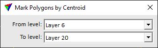
The Mark Polygons by Centroid dialog opens:
3. Define settings.
4. Place a data click inside a view.
This moves polygons to the target level if their centroid is inside the selected bounding polygons. An information dialog shows the number of moved polygons.
SETTING |
EFFECT |
|---|---|
From level |
Source layer from which polygons are checked. |
To level |
Target layer to which polygons are moved. |