

TerraScan User Guide
Cut long range
Not Lite
Cut long range command cuts off long range measurements if there are shorter measurements from the same line closeby. This is suited for point clouds from mobile/backpack/handheld scanners which may see the same location multiple times in a single line. The main purpose of the process is to reduces the noise level in the data set as longer measurements may be less accurate.
To cut long range points:
1. Select Cut long range command from the Line pulldown menu.
This opens the Cut Long dialog:
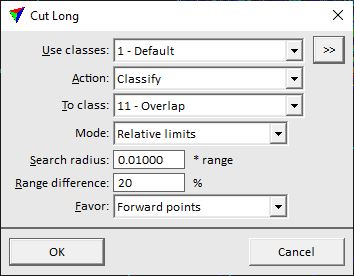
2. Define settings and click OK.
This starts the process.
SETTING |
EFFECT |
|---|---|
Use classes |
Point class(es) that are considered in the process. |
|
Opens the Select classes dialog which contains the list of active classes in TerraScan. You can select multiple source classes from the list that are then used in the Use classes field. |
Action |
Action to perform on points that are cut off: •Classify - classify points into one target class. •Delete - remove points from the data set. •Set overlap bit - sets the overlap bit for points in LAS 1.4 files. |
To class |
Target class for points that are cut off. This is active only if Action is set to Classify. |
Mode |
Determines how long measurements are defined: •Absolute limits - fixed Search radius and Range difference settings are used. •Relative limits - the Search radius depends on the range from the scanner and the point density is taken into account. |
Search radius |
Radius from a point within which the software searches for shorter range points. A point is cut off if another point with a shorter range is found within the given radius. Fixed value for Absolute limits and factor of the range from scanner for Relative limits. |
Range difference |
Maximum allowed range difference of two points. Only if the range difference is smaller, the longer range point is cut off. Expressed in CAD file units for Absolute limits and percentage for Relative limits. |
Favor |
Points may be favored to keep depending on the scan direction: Forward points or Backward points. If all points should be treated the same, select Nothing. This is active only if Mode is set to Relative limits. |
