

TerraPhoto User Guide
Define Rendering Settings
 Define Rendering Settings tool defines settings for rendering views with TerraPhoto tools.
This concerns levels in the active CAD file or in a reference CAD file that are used to drape the raster references, e.g. orthophotos, on when a view is rendered. These levels have to contain vector models of objects, e.g. building roofs, which are used for draping.
The backside color refers to the display of backsides of 3D planes. When 3D planes are rendered, the normal direction of the plane determines the frontside and backside of the plane. Textures and lightning are usually applied to the frontside of planes, while backsides are displayed using a constant color and in shadow.
Further, the settings define how raster materials are used as textures and how laser points are drawn in relation to vector elements.
To define rendering settings:
1. Select Define Rendering Settings tool.
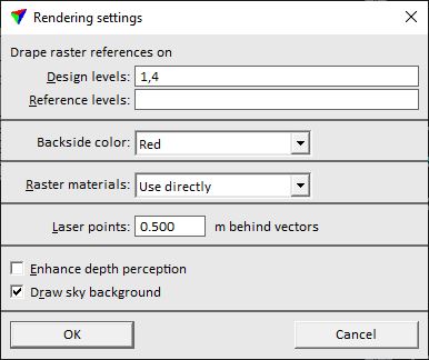
This opens the Rendering settings dialog:
2. Define settings and click OK.
The settings are used by the TerraPhoto tools Display Rendered View and Save Rendered View, as well as in frame and movie creation with Create Flythru Movie tool.
SETTING |
EFFECT |
|---|---|
Design levels |
Levels in the active CAD file used for draping raster references on vector elements. Separate several levels by comma. Raster reference draping overrides textures assigned to affected CAD elements. |
Reference levels |
Levels in attached reference CAD file used for draping raster references on vector elements. Separate several levels by comma. Raster reference draping overrides textures assigned to affected CAD elements. |
Backside color |
Display color for the backside of 3D planes: •Element color - the color of the element is used. •Red - backsides are displayed in red color. •Green - backsides are displayed in green color. •Blue - backsides are displayed in blue color. |
Raster materials |
Defines how raster files are used as textures: •Do not use - no textures are displayed. •Use directly - texture files are used in TerraPhoto rendering. |
Laser points |
Determines the distance of laser points behind vector elements in rendered views. This effects only the display of the points in views created with TerraPhoto rendering tools. |
Enhance depth perception |
If on, an advanced rendering method is applied. Objects closer to the viewer are highlighted from objects farther away from the viewer. |
Draw sky background |
If on, a sky background is drawn in rendered perspective views. This may lead to a more realistic visualization, especially for mobile ground-based data sets. |