

TerraPhoto User Guide
Fields
Fields command lets you select which attributes are displayed for each image in the image list. The command is only active if the TPhoto window size is set to a Small dialog or Large dialog.
To select visible fields:
1. Select Fields command from the View pulldown menu.
This opens the View image fields dialog:
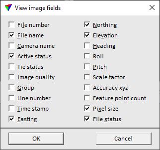
2. Select fields and click OK.
FIELD: |
DESCRIPTION: |
|---|---|
File number |
Internal image number. |
File name |
Name of the image file. |
Camera name |
Name of the camera that captured the image. |
Active status |
Image status for ortho rectification. |
Tie status |
Image status for placing tie points. |
Image quality |
Number that indicates the quality of the image. |
Group |
Group number of the image. |
Line number |
Line number of the image. |
Time stamp |
Time stamp of the camera position when the image was captured. |
Easting |
Easting coordinate of the image position (focal point). |
Northing |
Northing coordinate of the image position (focal point). |
Elevation |
Elevation coordinate of the image position (focal point). |
Heading |
Heading angle of the image orientation. Given in degree. |
Roll |
Roll angle of the image orientation. Given in degree. |
Pitch |
Pitch angle of the image orientation. Given in degree. |
Scale factor |
Scale factor defined in the mission and applied when an image list is created. |
Accuracy xyz |
Accuracy estimate of the image xyz positioning. |
Feature point count |
Amount of feature points located in the image area. |
Pixel size |
Size of a raw image pixel on a rectification surface. |
File status |
Indicates whether the image file is available in the image directory on the hard disk or not. |