

TerraPhoto User Guide
Blur selected polygons
Not Lite, Not UAV
Blur selected polygons command can be used to increase the pixel size inside specified areas. The areas are defined by 3D polygons, such as roof shapes. The command can be used to blur classified areas, such as military properties.
You can use the preview of an ortho mosaic as a background for identifying areas to blur. Laser data or other point cloud data can be useful to create 3D polygons. The process can be performed on one or several selected polygons.
The process effects the original raw images referenced by the image list.
To blur a selected area:
1. Draw a polygon around the area to blur. Create a 3D shape, for example by draping the shape to laser points with TerraScan Drape linear elements tool.
2. Select the polygon using any Selection tool of the CAD platform.
3. Select Blur selected polygons command from the Utility pulldown menu.
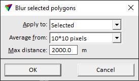
This opens the Blur selected polygons dialog:
4. Define settings and click OK.
This opens an Alert dialog which shows the number of effected raw images and asks for confirmation of the action.
5. Click OK in order to start the process.
The software starts to manipulate the original raw image(s) according to the settings in the dialog. A dialog shows the number of effected images when the process is finished.
Setting |
effect |
|---|---|
Apply to |
Images that are effected by the process: •All - all images that are inside the selected polygon(s). •Selected - images that are selected in the image list. •<camera name> - images of the selected camera. |
Average from |
Amount of pixels from which color values are averaged in the blurring process. The larger the amount, the bigger is the blurring effect. |
Max distance |
Maximum distance from the image position to the polygon(s). If an image is further away, the blurring is not applied. |