

TerraModeler User Guide
Label Peaks and Pits
 Label Peaks and Pits tool draws labels for the highest point on hill tops and the lowest points inside depressions into the CAD file. The label contains a text showing the elevation value and a point marker placed at the location of the elevation point.
The layout of the label is determined by the settings in Elevation labels category of the TerraModeler Settings.
From the dialog of the tool, a peaks and pits settings file can saved for being used in automatic contour production. See Utility / Produce contours for more information. The settings file stores all information given in the dialog except the surface model name.
To draw peaks and pits into the CAD file:
1. Select the Label Peaks and Pits tool.
This opens the Label Peaks and Pits dialog:
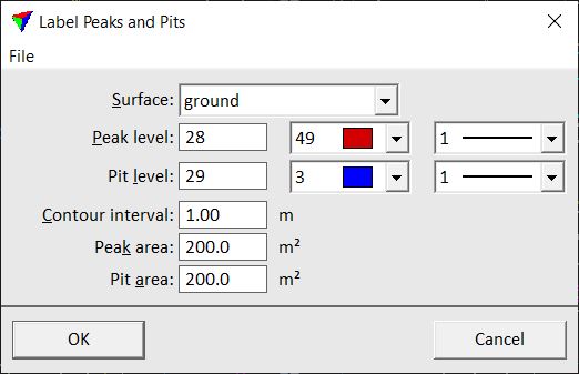
2. Define settings for peaks and pits display.
OR
2. Load a previously saved settings file into the dialog using the Load settings command from the File pulldown menu.
3. (Optional) Save the settings into a file on a hard disk by using the Save settings As command from the File pulldown menu.
Click Cancel to the Label Peaks and Pits dialog if you just want to save a peaks and pits settings file for automatic contour line production.
4. Click OK to the Label Peaks and Pits dialog.
The software searches for peaks and pits in the surface model and writes the labels into the CAD file.
Setting |
Effect |
|---|---|
Surface |
Name of the effected surface model. |
Peak level |
Level, color, and line weight of labels for peaks. Uses the active CAD file color table and line weights. |
Pit level |
Level, color, and line weight of labels for pits. Uses the active CAD file color table and line weights. |
Contour interval |
Distance between two consecutive contour lines. |
Peak area |
A peak label is placed if the area enclosed by the biggest closed contour line around a hill top is at least as big as the given value. |
Pit area |
A pit label is placed if the area enclosed by the biggest closed contour line around a depression is at least as big as the given value. |