

TerraModeler User Guide
Flatten Area
 Flatten Area tool flattens surface model points to a fixed elevation. The tool sets the elevation of all points inside or outside a fence.
You can enter the new elevation as a key-in value or as a data point.
The fence can be defined by a fence or shape element. Valid element types include shapes, complex shapes and ellipses.
To flatten area points to a fixed elevation:
1. Place a fence or a shape element to define the area. (Optional) Select the shape.
2. Select the Flatten Area tool.
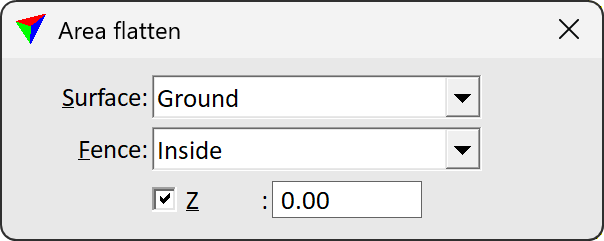
The Area flatten dialog opens:
3. Define settings.
4. Identify the bounding shape for the area, if a shape element is used and not selected already.
5. Accept the fence contents with a data click. The data point determines the new elevation value for the surface points if Z is switched off.
The points are moved to the given elevation.
Setting |
Effect |
|---|---|
Surface |
Name of the effected surface model. |
Fence |
Defines where points are effected: •Inside - points inside the fence are modified in elevation. •Outside - points outside the fence are modified in elevation. |
Z |
Elevation value to which points are moved. If on, the points are fixed to the given elevation value. If off, points are fixed to an elevation value given by the data point in step 5. |
Flatten Area tool can be used for creating a flat plane inside a model. However, this operation alone does not produce a flat area with an exact boundary because the tool does not clip the triangles overlapping the fence border. The tool effects only the points inside the area. After the operation the surface model may start sloping down or up within the area boundary.
In order to create an exactly bounded flat area, you have to add the boundary lines to the surface model and make sure that triangles do not overlap the boundary.
General procedure for creating a flat plane:
1. Place a shape element to define the area.
2. Set the elevation of the shape element using the Set Linear Elevation tool.
3. Add the shape element as Hard breakline points to the surface model using the Insert Breakline Element tool.
4. Select the shape element.
5. Start the Flatten Area tool to fix all the points inside the bounding element to the desired elevation.