

TerraModeler User Guide
Export / Triangle text file
Triangle text file command creates a text file from surface model triangles. The triangles can be written into simple text files for points and edges, into exchange format text files, such as LandXML, or into survey application-specific text files. Supported triangle text file formats are 4ce DOT, GMS, InfraModel 4.0, ICC, Moss triangulation, LandXML 1.0/1.2, Point & edges text file, Surpac DTM triangulated model, SMS / WMS and WorldToolKit NFF.
To create a text file from surface model triangles
1. Select Triangle text file command from the File / Export pulldown menu.
The Export Triangle Text File dialog opens:
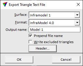
2. Select a Surface for which to export the triangles.
3. Select a Format for the output file.
4. If required by the format, define additional settings.
5. Click OK.
This opens another Export triangle text file dialog, a standard dialog for saving files. If triangle points and edges are saved into separate files, the dialog opens for a second time after saving the first file.
6. Enter a name for the output file and click OK.
This saves the triangles into the text file(s).
Setting |
Effect |
|---|---|
Surface |
Name of the surface model for which to export the triangles. The list includes all surface models that are open in TerraModeler. |
Format |
Format of the output file. Any additional settings depend on the selected format for the output file. |
ID |
Surface identifier for GMS triangle files. |
Output name |
Name of the surface model written into LandXML 1.0, LandXML 1.2 and Inframodel files. |
Prepend file name |
If on, the model's Output name is added to the Surface name tag in LandXML 1.2 and InfraModel files. Example: <Surface name="output file name - model name"> |
Write excluded triangles |
If on, excluded triangles are written into LandXML 1.2 and InfraModel files. |
Header |
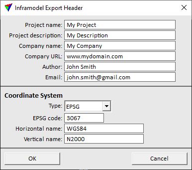
Opens the Inframodel Export Header dialog which allows the input of metadata for InfraModel files. |
Y Axis up |
If on, the coordinate system is rotated in a way that the Y axis points up for exporting triangle coordinates into WorldToolKit NFF files. |
Output textures |
If on, domain-related texture information is written into WorldToolKit NFF files. |
The Inframodel Export Header dialog lets you define metadata for InfraModel ouput files.
Setting |
Effect |
|---|---|
Project name |
Free text for the Project name tag. |
Project description |
Free text for the Project desc tag. |
Company name |
Free text for the Author company tag. |
Company URL |
Free text for the Author companyURL tag. |
Author |
Free text for the Author createdBy tag. |
Free text for the Author createdByEmail tag. |
|
Type |
Type of coordinate system definition: EPSG or Other. |
EPSG code |
Code number of an EPSG coordinate system definition. This is only active if Type is set to EPSG. |
Horizontal name |
Name of the ellipsoid definition. |
Vertical name |
Name of the height system definition. |