

TerraScan User Guide
Split at laser gaps
Split at laser gaps command cuts trajectories if there is a gap in laser data. It removes part of trajectories where there is no laser data available.
The command requires points or a project loaded into TerraScan. It is best suited, if the scanner was turned off during the survey or if only a part of captured data is processed in a TerraScan project.
To split trajectories at laser gaps:
1. (Optional) Select the trajectory file(s) you want to cut in the Trajectories window.
2. Select Split at laser gaps command from the Tools pulldown menu.
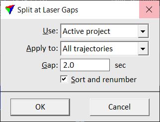
This opens the Split at Laser Gaps dialog:
3. Define settings and click OK.
This deletes all trajectory parts outside the area covered by laser data. The application deletes the old trajectory file(s) and creates new files in the active trajectory directory. An information dialog shows the result of the process.
SETTING |
EFFECT |
|---|---|
Use |
Source data used for detecting gaps in a point cloud: •Loaded points - points loaded into TerraScan. •Active project - points referenced by the active TerraScan project. Not UAV |
Apply to |
Trajectories effected by the process: All trajectories or Selected only. |
Gap |
Minimum time interval that defines a gap in the laser data. If there is data missing for a longer time, the trajectory is split. |
Sort and renumber |
If on, the trajectories are sorted by time and renumbered after splitting. |