

TerraScan User Guide
Set Polygon Elevation
 Set Polygon Elevation tool sets the elevation of a closed element based on laser points inside it.
This tool is typically used to drape a digitized 2D shape to the elevation of laser points on a building roof or a bridge. All vertices of the shape are set to the same elevation value derived from laser points.
Valid CAD element types include shapes, complex shapes, and ellipses. You can fit several selected elements in a single process.
To set the elevation of a closed element:
1. (Optional) Select elements for which you want to set the elevation.
2. Select the Set Polygon Elevation tool.
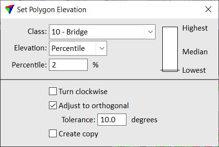
This opens the Set Polygon Elevation dialog:
3. Define settings.
4. If elements have been selected, start the process with a data click inside the CAD file view.
This computes an elevation value from laser points for each selected element and adjusts all selected elements.
OR
4. Identify the element to adjust with a data click.
This highlights the element.
5. Accept the highlighted element with a data click inside the CAD file view.
This computes an elevation value from laser points and adjusts the element. You can continue with steps 3 or 4.
SETTING |
EFFECT |
|---|---|
Class |
Point class from which to derive the elevation. Only points inside the shape element are used. |
Elevation |
Method of elevation computation: •Percentile - elevations from the given Percentile value of points. The scale shows which percentile of points is used: Lowest, Median, or Highest points, and can be used to set the percentile value with a data click. •Average - average of all laser point elevation values inside the shape. |
Turn clockwise |
If on, the drawing direction of the adjusted shape is forced to run clockwise. |
Adjust to orthogonal |
If on, the corner angles of the adjusted shape are fixed to 90 degree turns if the angles of the original element are within the Tolerance value off from 90 degrees. |
Create copy |
If on, a new element is created and adjusted using the active level and symbology settings of the CAD file. If off, the original element is modified. |