

TerraScan User Guide
Fix elevation
 Fix Elevation tool fixes elevation values of points to a constant value. The tool processes data inside limited areas that can be defined by selected polygons, polygons on a given CAD file level, or a fence.
This tool may be useful, for example, to get a smooth surface from points on water.
To fix elevations of points:
1. Use CAD platform tools to draw polygons or a fence around the area(s) for processing. Select polygons, if required.
2. Select the Fix Elevation tool.
The Fix Elevation dialog opens:
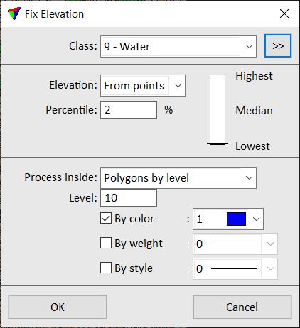
3. Define settings and click OK.
This sets the elevation values of the laser points in the selected class(es) and inside the processing area to a constant elevation value.
4. Use Save points or Save points As commands in order to save changes to point classes permanently into a laser point file.
SETTING |
EFFECT |
|---|---|
Class |
Source class(es); only points from selected class(es) are effected. The list contains the active classes in TerraScan. Alternatively, points from multiple classes or Any class can be selected. |
|
Opens the Select classes dialog which contains the list of active classes in TerraScan. You can select multiple source classes from the list that are then used in the Class field. |
Elevation |
Method of calculating the constant elevation value: •From points - elevation derived from the given Percentile value of points. The scale shows which percentile of points is used: Lowest, Median, or Highest points, and can be used to set the percentile value with a data click. •Keyin value - absolute elevation value given in the Value field. |
Process inside |
Determines the processing area: •Fence - points inside a fence are effected. •Selected polygons - points inside selected polygons are effected. •Polygons by level - points inside polygons drawn on the given CAD file Level are effected. The polygons can be further specified by selecting By color, By weight, and/or By style options. The selection lists use the active color table, line weights and line styles of the CAD file. |
